

Latest Weather Blog
Thursday PM Forecast: only a few showers to dodge next two days, some may miss rain
Though the best rain chances in more than a week will hold in the forecast through Friday, no washouts are expected and some locations may miss rain entirely, especially north and west of Baton Rouge. A cold front will move through early next week, sending humidity much lower.
Tonight & Tomorrow: Mainly cloudy skies will stick around during the overnight hours. It is possible that a few showers hang on, especially near the coast, but this will be the exception rather than the rule. Low temperatures will be muggy in the low 70s. Thanks to some tropical moisture and a weak, stalled front, there may be some isolated showers and thunderstorms around on Friday. Total rain coverage will be on the order of 40 percent but know that areas south and east of Baton Rouge are the most likely to see precipitation while many other areas will get skunked. Due to the added cloud cover, high temperatures will keep to the upper 80s. Any leftover showers will be diminishing into evening highs school football games, but it would be a good idea to take a precautionary poncho.
Up Next: The weekend will trend drier. While some showers remain possible on Saturday, especially south of I-10, those with outdoor activities should not fear any major disruptions. That would include Southern Jaguars football. For the game against Nichols State, aside from a spotty afternoon shower, clearing skies are expected by kickoff with a muggy temperature in the low 80s. Sunday looks even less likely to deal with any showers. Both afternoons will be partly sunny with highs near 90 degrees.
On Monday, moisture will diminish as we await the arrival of a cold front. This front will push through during the evening hours followed by the coolest and driest air so far this season. Despite sunshine, high temperatures will stay in the mid 80s on Tuesday. By Wednesday morning, low temperatures will dip into the low 60s. Some spots north of the city could reach the upper 50s for the first time this fall.
Get the latest 7-day forecast and real time weather updates HERE.
Trending News
Watch live news HERE.

The Tropics: Hurricane Kirk is a major storm packing maximum sustained winds of 130mph over the central Atlantic Ocean. While no direct impacts to land are anticipated, some swells could reach the United States this weekend. Kirk may strengthen further while moving northwest over open water.
Following Kirk is Tropical Storm Leslie which is also gradually getting better organized. Maximum sustained winds of 45mph will intensify with a hurricane expected as the storm moves west and then northwest following Kirk out to sea.
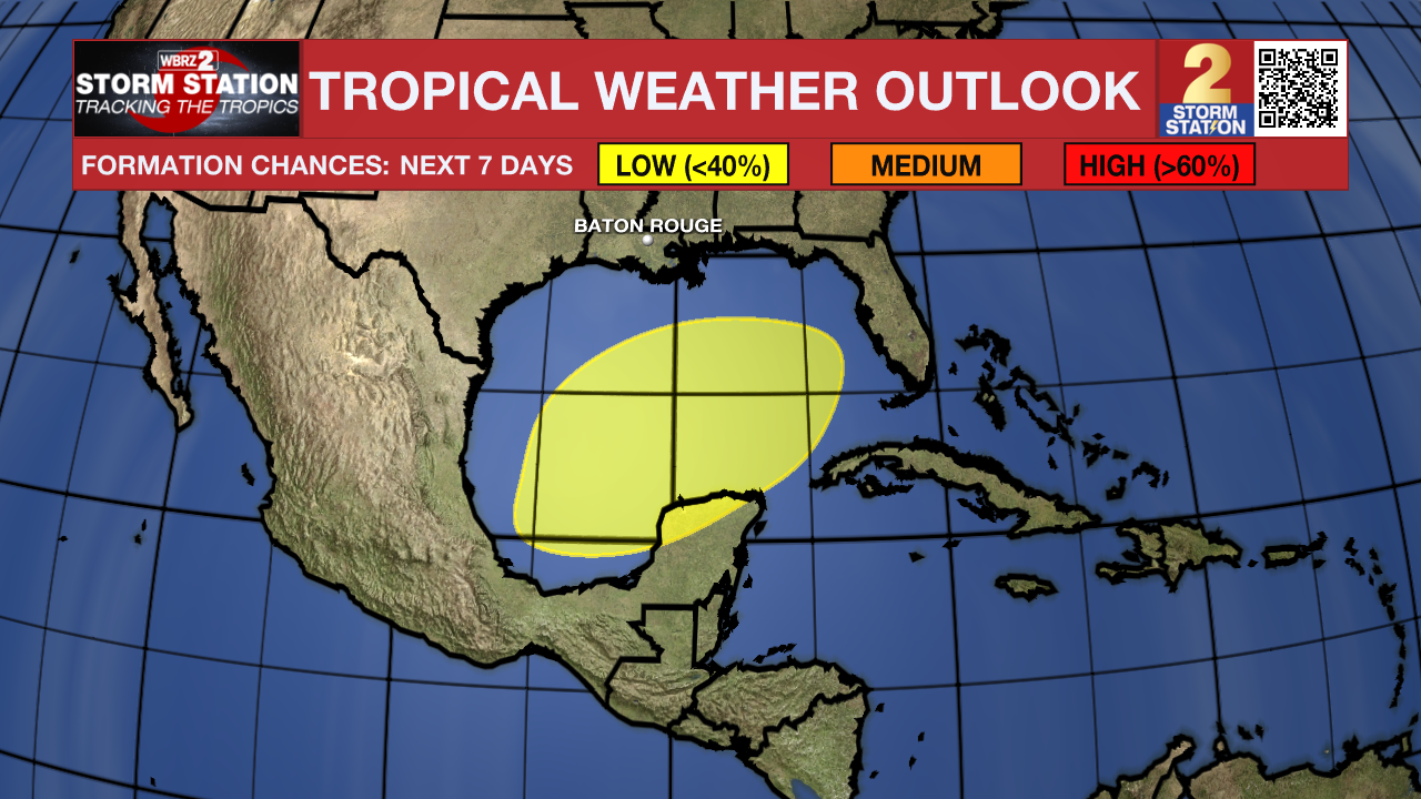
Disorganized showers and thunderstorms over portions of the Gulf of Mexico are associated with a surface trough. A broad area of low pressure is likely to develop over the Gulf of Mexico this weekend or early next week, but subsequent tropical or subtropical development could be limited by the system's potential interaction with a frontal boundary. Regardless of development, locally heavy rains could occur over portions of Mexico during the next few days and over portions of the Florida Peninsula from late this weekend into next week.
– Josh
The Storm Station is here for you, on every platform. Your weather updates can be found on News 2, wbrz.com, and the WBRZ WX App on your Apple or Android device. Follow WBRZ Weather on Facebook and Twitter for even more weather updates while you are on the go.
More News
