

Latest Weather Blog
Friday AM Forecast: Temperature rollercoaster this weekend, Strong storms Saturday night
After a cool Valentine's Day, temperatures will heat back up on Saturday ahead of a strong line of thunderstorms set to move across the state Saturday night. Behind the storms, expect another cool down that will last well into the next week.
Today & Tonight: Partly sunny skies Friday morning will see an increase in cloud cover by lunchtime. Mostly cloudy skies and cool temperatures in the 60s are to be expected Friday afternoon. Winds will be lighter than on Thursday, out of the east between 5-15 mph. Besides a spotty shower or two, conditions will be dry for those heading out to Opening Day for LSU Baseball or with Valentine's dinner reservations; it is advised to bring an extra layer or two to any outdoor events!

Saturday: Saturday will be warm and windy! A warm front will push through the Capital Region early Saturday morning, making for a mild and muggy start to what will become a warm and partly sunny afternoon. Look for highs on Saturday in the mid-80s. Winds will increase to sustained speeds of 15-25 mph with gusts as high as 35 mph out of the south.
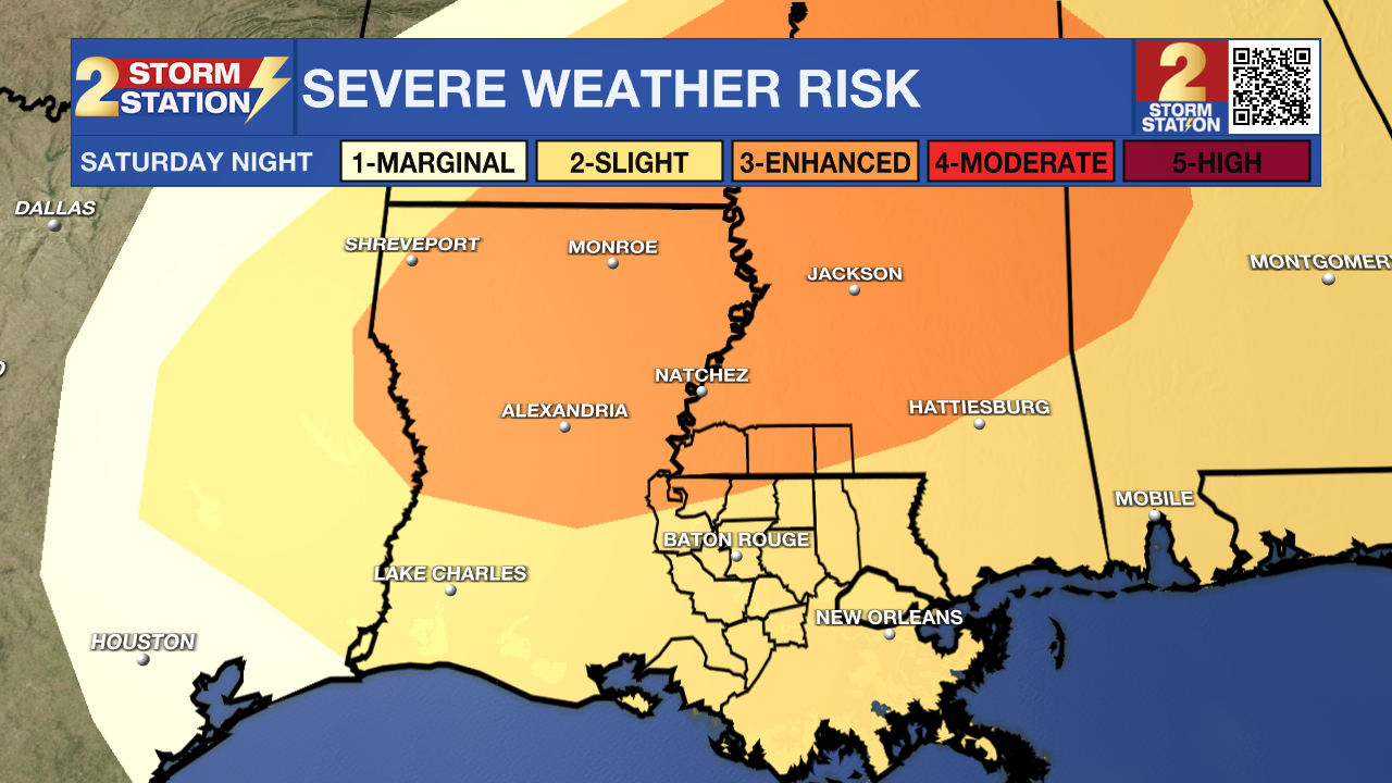
While daytime hours will be mostly dry, an approaching cold front from the west will increase rain and storm coverage during late afternoon and evening hours. Along the approaching front, a line of strong to severe storms could develop. Latest data suggests this system will reach the Capital Area overnight, anytime between 10pm and 5am. The highest threat for severe weather remains just to the north of Baton Rouge, but we cannot rule out isolated severe warned storms in the Capital Area (see below).
Trending News
Next Severe Weather Chance – This storm event will likely come down to timing. Current information suggests that the most intense weather, including a line of storms, will move in during the evening and overnight hours.
Later at night, upper-level winds will be supportive of strong thunderstorms, but by then, the energy for storms will be decreasing. The best storm energy will be available earlier in the day, but at that point, the upper-level winds won’t be as supportive. If at some point these two factors can overlap, there could be a more favorable window for severe weather.
Given the expected setup, the most likely outcome is a squall line of rain and thunderstorms with damaging wind gusts being the main concern. As for tornado potential, the low-level winds that help create rotation don’t look particularly impressive—just enough to maybe support a brief tornado, especially on the leading edge of the squall line.
The Baton Rouge Area and points south are included in a 2/5 “slight risk” category, while areas near and north of the state line are in a 3/5 “enhanced risk” for severe weather. This indicates the potential for isolated to scattered severe weather events within the risk area.
Sunday & Beyond: Early Sunday, the cold front will continue east as a breezy northerly wind behind the system quickly usher in colder and drier air. Into the next workweek, cooler-than-average temperatures will settle in. On Monday morning, most areas will be in the 30s, with parts of southwest Mississippi dipping into the upper 20s. As the workweek begins, dry air will maintain cool, clear conditions. However, this setup won’t last long—upper-level steering winds will shift to a more west-to-east pattern on Tuesday, leading to a slight and brief warm-up. On Wednesday, the previous cold front will lift back north over the central Gulf, setting the stage for unsettled weather. Another cold front will move into the southern United States as a storm system forms near the warm front in the Gulf. This combination of features will bring the next chance for rain during the middle of next week. Another shot of cool air may follow this for the end of next week.
Get the latest 7-day forecast and real-time weather updates HERE.
Watch live news HERE.
– Emma Kate C.
The Storm Station is here for you, on every platform. Your weather updates can be found on News 2, wbrz.com, and the WBRZ WX App on your Apple or Android device. Follow WBRZ Weather on Facebook and X for even more weather updates while you are on the go.
More News
