

Latest Weather Blog
Friday AM Forecast: Storm chances increase as we head into this big football weekend
Scattered showers and storms will remain in the forecast Friday, but rain chances move even higher over the weekend. This could impact both LSU and Southern football.
Today & Tonight: Similar to Thursday, scattered showers and storms will be possible today. These will be primarily in the afternoon and evening, with storms fizzling in the overnight hours. Heavy rain and brief gusty winds will be possible in thunderstorms. Other than the rain, it will be warm and humid with highs in the lower 90s. Lows tonight will be near 73°.

High School & College Football
• Friday Night: Anyone heading to a high school football game may want to keep rain gear handy. While rain chances will be decreasing, a few lingering showers and thunderstorms could stick around into the evening and potentially lead to brief delays before games are able to wrap up.
Trending News
• Saturday (LSU & Southern): If you plan to spend a good portion of the day on either campus, be sure to bring rain gear, a poncho, and shoes that can handle some wet or muddy conditions. Rain will not be constant, but periods of showers and thunderstorms will remain possible throughout the day. It is still too soon to know whether storms will directly impact game times, although the afternoon currently appears to have the greatest coverage. One upside is that clouds and rain should keep temperatures lower than during previous games, although humidity will remain quite high.

Use the slider to advance through the next 24 hours of Futurecast
Up Next: The weather setup becomes much wetter this weekend as two separate systems influence the region. A tropical disturbance moving northwest from the Caribbean will bring in deep moisture, while a front slowly approaches from the west. With atmospheric moisture levels climbing to values rarely seen this time of year, some areas may see episodes of very heavy rain through Sunday. Here are the main things to know:
• Rain Coverage: Saturday and Sunday will both carry an 80% coverage for rain, so showers and thunderstorms will be common across the area. That does not mean it will rain nonstop. Activity should come and go, with stretches of dry weather between rounds.
• Rain Totals: By the end of Sunday, most communities across the Capital Area will likely pick up between 1 and 4 inches of rain. The lowest totals are favored north and west of Baton Rouge, while areas farther south and east stand a better chance of seeing the higher amounts.
• Flood Concerns: The bigger concern will be how quickly rain can fall beneath stronger thunderstorms. A few localized spots could briefly see rainfall rates over 4 inches per hour. Even if those extreme rates do not last long, they would be enough to overwhelm drainage systems, flood poor-drainage areas, and create standing water on roads and in underpasses. The good news is that rivers and bayous are currently running low, so widespread river flooding is not the primary concern.
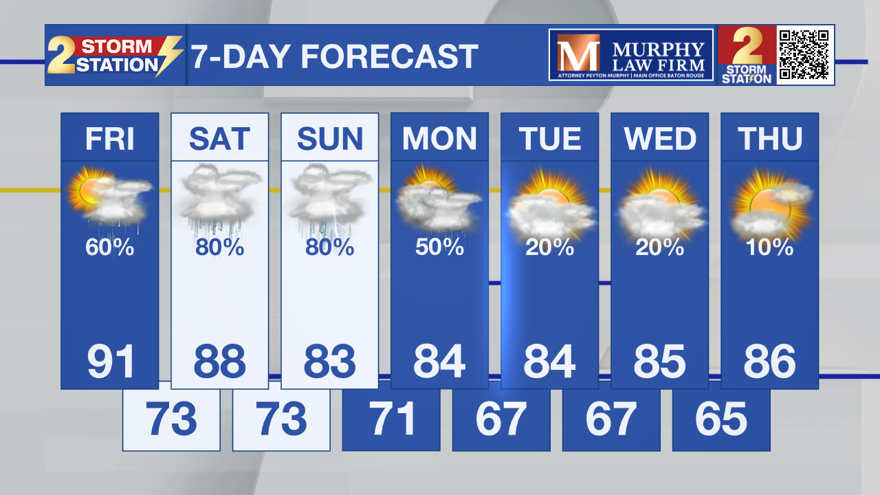
The unsettled pattern begins to ease early next week as the main system shifts south toward the Gulf. By Monday, afternoon temperatures should top out in the mid-80s, while mornings turn a little more comfortable, with lows reaching the upper 60s by Tuesday. A modest drop in humidity will also limit daily shower coverage to around 20–30%. Looking farther ahead, another push of cooler air may arrive late next week, potentially bringing highs down to the low 80s and overnight lows into the low 60s.
Get the latest 7-day forecast and real-time weather updates HERE.
Watch live news HERE.

The Tropics: An area of low pressure associated with the remnants of former Tropical Storm Fay is located several hundred miles southeast of Bermuda. Despite ongoing thunderstorm activity, dry air and strong upper-level winds are expected to prevent significant re-development while it moves northwestward, to the east of Bermuda. Any formation chances should end by Sunday due to very strong upper-level winds.
– Balin
The Storm Station is here for you, on every platform. Your weather updates can be found on News 2, wbrz.com, and the WBRZ WX App on your Apple or Android device. Follow WBRZ Weather on Facebook and X for even more weather updates while you are on the go.
More News

