

Latest Weather Blog
Friday PM Forecast: a few showers to dodge this weekend, stronger storm system next week
Our first chance at measurable rain in nearly a month will arrive just in time for Halloween weekend. As a reminder, set those clocks back one hour before bed on Saturday night! Looking further ahead, keep rain gear handy and stay alert for a round of thunderstorms that will sweep across southeast Louisiana around Election Day.
Halloween Trick: showers possible for the first time since early in the month
Muggy for a While: weekend into early next week
Stronger Frontal: more widespread rain, temperature tumble Election Day onward

Trending News
Tonight and The Weekend: An influx of moisture and humidity coupled with a weak storm system will allow scattered showers through Sunday. Overnight will be warm and muggy with lows in the mid 60s. Occasional showers are possible, especially near dawn. Halloween Saturday will be unseasonably warm with high temperatures running into the low 80s, and it will feel sticky at times. Intermittent showers will speckle the map, but most of the time will be dry; some neighborhoods may miss rain, and those that receive it will not get much. As for trick-or-treat time, the evening is one of the more favorable times for showers to flare up. By Sunday, shower activity should trend down from west to east with temperatures remaining mild.
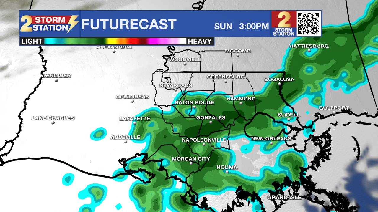
Use the slider to advance through the next 24 hours of Futurecast
Up Next: The new week will continue the trend of warm temperatures. However, by Tuesday afternoon into Wednesday morning—surrounding Election Day—a powerful storm system will barrel across the Gulf South. Unlike the weekend showers, this system will have the necessary support in the atmosphere for more widespread rain and thunderstorms. Expect rain coverage to ramp up Tuesday evening and increase overnight Tuesday, persisting into Wednesday morning. Once the front clears Wednesday afternoon, it will usher in crisp, dry air, dropping daytime highs into the upper 70s and overnight lows into the 50s for the remainder of the workweek.
Get the latest 7-day forecast and real-time weather updates HERE.
Watch live news HERE.
The Tropics: The Gulf, Caribbean, and broader Atlantic Basin will remain completely quiet. Tropical cyclone formation is not expected over the next 7 days.
– Josh
The Storm Station is here for you, on every platform. Your weather updates can be found on News 2, wbrz.com, and the WBRZ WX App on your Apple or Android device. Follow WBRZ Weather on Facebook and X for even more weather updates while you are on the go.
More News

