

Latest Weather Blog
UPDATE: Gusty storms moving through Capital Region, parishes removed from Tornado Watch
UPDATE - 1 a.m. Monday: Gusty storms continue to roll through the Capital Area. For instance, Baton Rouge saw winds gusting to 44 mph around 12:45 a.m., just as temperatures plunged. Metro Airport registered a 17° drop in temperatures from 12:35 a.m. to 12:53 a.m. (72° → 55°). All storms have remained sub-severe up to this point. That said, the Storm Station is continuing to monitor closely for any sudden flare-ups. Storms will be through in the next hour or two.
While many will escape severe weather, isolated instances of it cannot be ruled out. The main concerns are gusty winds, a tornado or two, and spotty large hail. Stay weather-aware for the next couple of hours. Download the Storm Station Weather App, and ensure your alerts are turned on to receive any immediate warnings. View the latest radar imagery below:

The Tornado Watch has been cancelled for Pointe Coupee, West Feliciana, and East Feliciana Parishes, as well as Amite and Wilkinson Counties. The severe weather threat is over for these areas. The Watch remains in effect for East Baton Rouge, West Baton Rouge, Ascension, Iberville, Livingston, St. Helena, and Tangipahoa Parishes until 4 a.m. Monday.
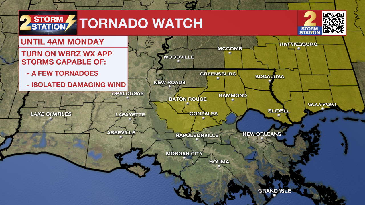
A TORNADO WATCH means conditions are favorable for tornadoes and/or damaging winds in and around the watch area. Be on the lookout for threatening weather conditions and listen for later statements and possible warnings. If a tornado warning is issued, seek shelter in a low-level, interior room of a sturdy building. Take pets (on a leash) with you, have on hard-soled shoes, monitor storm coverage on a wireless device, and cover your head in the event of wind or tornado impact. For more on tornado safety, CLICK HERE.
Remember that the WBRZ WX App. is *free* on Apple and Android devices and can be used for breaking weather information, live radar, and forecast details. You can also use it to watch live coverage if power or broadcast signal is ever lost. For even more, connect with the Storm Station on X and Facebook. Stream WBRZ+ for continuous information as it becomes available.
Trending News
A strong cold front is about to kick the warm, spring-like feel out of the area. After a thin line of thunderstorms sweeps through late Sunday, a brisk northwest wind will usher in a significant cooldown for the Gulf Coast.
Tonight & Tomorrow: Once storms pass, expect a cold wind to take over on Monday. Starting off in the 40s, temperatures will only find the mid-50s by Monday afternoon. Multiple weather impacts are expected into Monday:
Strong Winds – The wind will be noticeable on Monday. Overnight, northwest winds at 15-25 mph with gusts topping 35 mph will take over once storms pass. The brisk wind will carry over throughout much of Monday. Go ahead and secure loose outdoor items if not already completed.
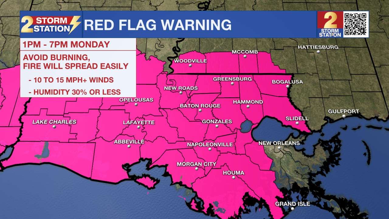
Fire Weather Danger – A Red Flag Warning has been issued for all of southeast Louisiana from 1 p.m. to 7 p.m. Monday. The combination of winds over 15 mph and very dry air will promote rapid widespread spread, should anything ignite. Avoid burning outdoors, dispose of cigarettes properly, and remain cautious while using equipment that can spark.
Significantly Colder – Jackets or heavier coats will be needed by morning, with wake-up temperatures in the 40s. The breeze will place wind chills into the upper 30s. After early clouds clear out, a mixture of sun and high clouds will warm highs into the mid-50s — significantly below average for late winter.
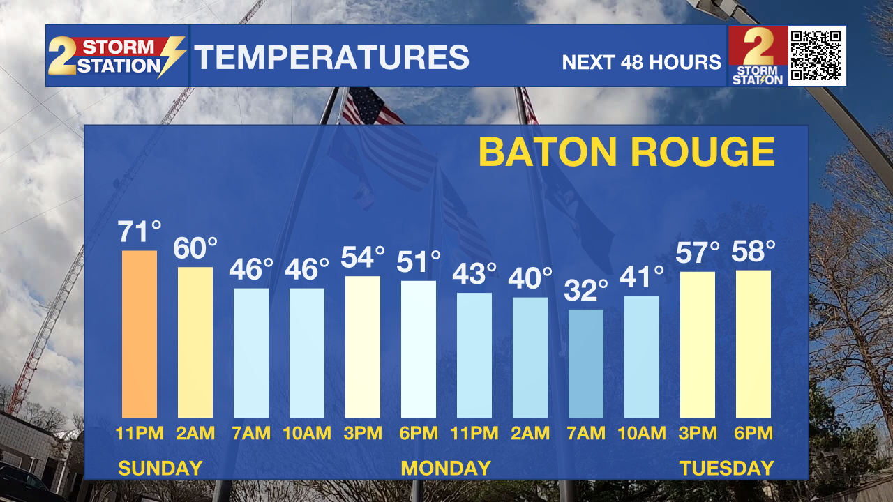
A Few Flakes? – If any sprinkles linger past dawn, don’t be surprised to see a few flakes mixing in. That said, most won’t come across those, and they certainly wouldn’t stick. By Monday afternoon, enough dry air invades to cut precipitation chances down to zero.
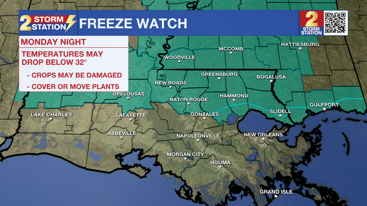
Up Next: The coldest part of the Storm Station forecast comes early Tuesday. A light freeze is expected along and north of I-10/12, with frost conditions south of the highways. Those who have planted their spring gardens will need to take action to protect plants. People and pets will also need a warm shelter. A Freeze Watch has been issued for areas north of I-10/12 on Tuesday morning, likely to be upgraded to a Warning later in time.
Temperatures will gradually moderate throughout the rest of the workweek, with generally dry conditions prevailing. As the week wraps up and spring begins, expect highs to return to the 80s.


Get the latest 7-day forecast and real-time weather updates HERE.
Watch live news HERE.
— Meteorologist Malcolm Byron
The Storm Station is here for you, on every platform. Your weather updates can be found on News 2, wbrz.com, and the WBRZ WX App on your Apple or Android device. Follow WBRZ Weather on Facebook and X for even more weather updates while you are on the go.
More News
