

Latest Weather Blog
Sunday AM forecast: Strong storms tonight and another blast of winter cold
Warm Sunday before late-night storms and a sharp cool down. A fast-moving line of storms arrives late Sunday night, followed by much colder air early next week.

Today and tonight: Sunday will start quietly across the Capital Region with partly to mostly cloudy skies and a warm, humid afternoon. Temperatures will climb into the lower 80s with south to southwest winds increasing to around 10 to 15 mph ahead of an approaching cold front.
Late Sunday night into the early hours of Monday morning, a line of showers and thunderstorms will sweep across Louisiana as the cold front pushes through the region. The timing currently looks to be roughly late evening through the overnight hours before storms exit by daybreak Monday.
Trending News

Use the slider to advance through the next 24 hours of Futurecast
Some storms could become strong to severe as they move through. Damaging straight-line winds will be the main threat, but a few brief tornado spin-ups cannot be ruled out as the storms organize into a fast-moving line.
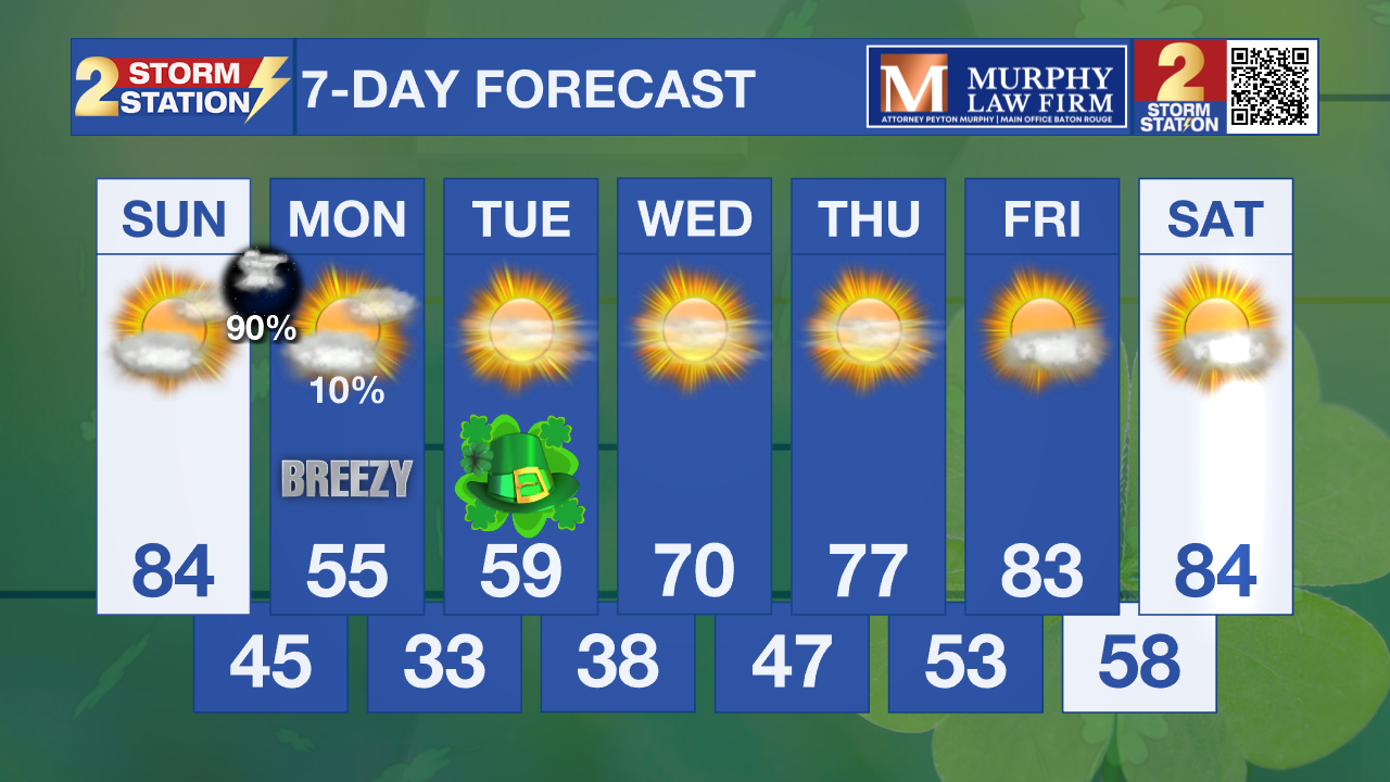
Up Next: Behind the front, temperatures will drop quickly with blustery northwest winds on Monday. Highs on Monday afternoon will struggle to reach the 50s despite sunshine returning.
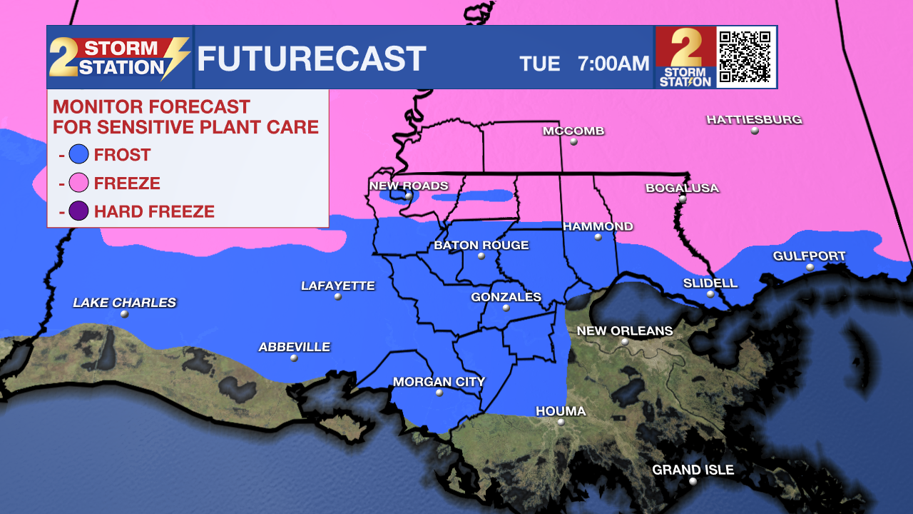
Even colder air will settle in on Monday night. Temperatures are expected to fall into the 30s, and areas north of the I-10/12 corridor could see temperatures near freezing early Tuesday morning; many other areas may have frost.
Conditions remain dry through midweek with a gradual warming trend. Highs should return to the 70s by Wednesday and could reach the lower 80s again by next weekend.
What to look out for: The Storm Prediction Center has placed the Capital area in a Level 2 Slight Risk for severe weather on Sunday. The setup favors a fast-moving line of storms. At this time, damaging winds look to be the largest threat, although a few spin-up tornadoes are possible. Hail will be more likely for far northern areas.
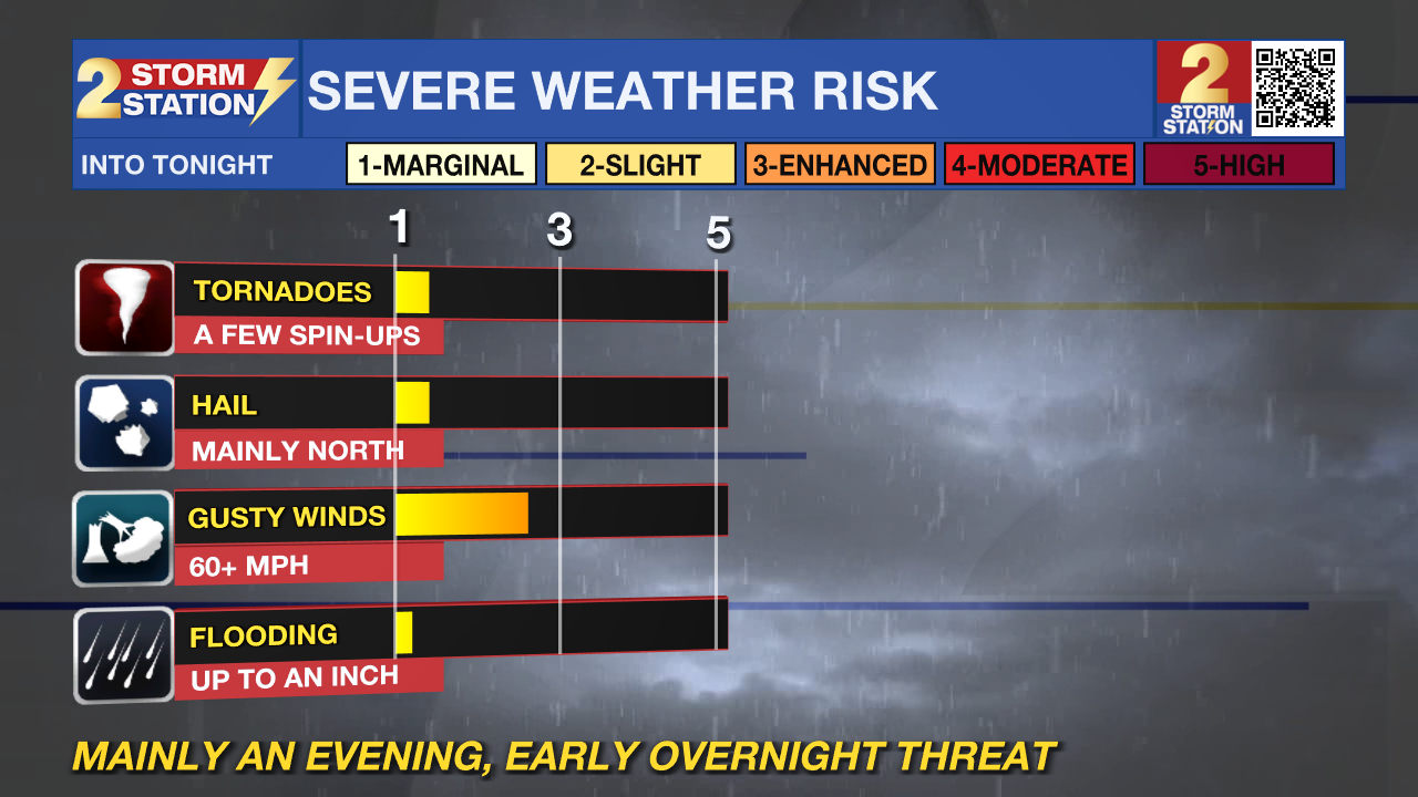
For our area, the main window for storms appears to be late Sunday night into very early Monday morning as the line sweeps quickly through the region.
Get the latest 7-day forecast and real-time weather updates HERE.
Watch live news HERE.
– Dave
The Storm Station is here for you, on every platform. Your weather updates can be found on News 2, wbrz.com, and the WBRZ WX App on your Apple or Android device. Follow WBRZ Weather on Facebook and X for even more weather updates while you are on the go.
More News
