

Latest Weather Blog
Tuesday PM Forecast: though still hot, slightly lower humidity coming for early days of fall
Wednesday onward, showers and thunderstorms will become scarce as drier air moves into the region. With this, we will also get some humidity relief, with mild mornings and warm afternoons late in the week and into the weekend.
At 7:04 pm Tuesday, astronomical fall begins. The season is defined by Earth’s orbit around the Sun, officially beginning at the autumnal equinox when day and night are nearly equal in length. Climatological fall is based on the annual temperature cycle and groups the three full calendar months of September, October, and November together for easier weather recordkeeping. While climatological fall always starts on a fixed date to align with temperature patterns, astronomical fall follows celestial positions and can vary slightly in start time each year.
The new season will get underway amidst one of the hottest Septembers on record for the Capital Area. 20 days this month have seen high temperatures above average. Even into the middle of the month, highs have stayed in the mid-90s. Only two days saw highs stop in the upper 80s when showers and thunderstorms halted warming.
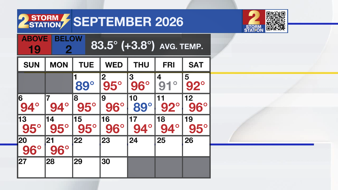
Through September 21, this month ranks as the third hottest on record going back to the 1890s. Only 2019 and 1921 have been hotter. With more 90s in the forecast, there is a chance this month could surpass 1921 and move into the second warmest spot on record.
Trending News
Humidity Relief: midweek front flushes highest humidity south
Drier Trend: several days without rain likely
Tropics: distant, weak activity with no local threats
Tonight and Tomorrow: Leftover showers will clear out quickly past nightfall with skies turning mostly clear. Expect low temperatures to level off in the low 70s. On Wednesday, a weak front will push across the Capital Region. Rather than bring cooler air, this front will scrape away the summer-like humidity, appropriately so for the first full day of astronomical fall. A stray shower or thunderstorm is possible as the boundary moves through, but most spots will stay dry. Look for high temperatures to top out in the mid 90s.

Up Next: For the second straight week, a taste of humidity relief will arrive for Thursday and Friday. We will wake up to seasonable, comfortable mornings with temperatures in the upper 60s. Since dry air warms and cools more efficiently than humid air, afternoons will still be hot with temperatures in the low 90s. However, feels-like temperatures, or the heat index, won’t be much higher than the thermometers due to the lower humidity.
That comfortable air will hold through Saturday before our wind flips back around to the south by Sunday. That shift will pump moisture right back into the area from the Gulf. By late weekend and early next week, we will feel a touch of humidity again, and that will support some pop-up, afternoon showers and thunderstorms.
Get the latest 7-day forecast and real-time weather updates HERE.
Watch live news HERE.

The Tropics: The Gulf and Caribbean remain completely calm, with no new development expected any time soon. Farther out in the open Atlantic, Fay has become post-tropical, spinning and weakening near the Azores. A new tropical disturbance will move off the coast of Africa Wednesday. It has a medium chance of development over the next 7 days as it tracks toward the Cabo Verde Islands.
– Josh
The Storm Station is here for you, on every platform. Your weather updates can be found on News 2, wbrz.com, and the WBRZ WX App on your Apple or Android device. Follow WBRZ Weather on Facebook and X for even more weather updates while you are on the go.
More News

