Record warmth continues, Rafael becomes a Major Hurricane
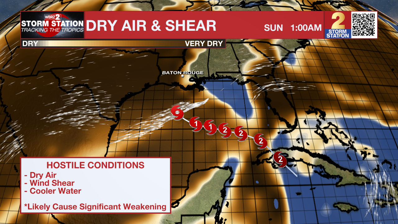
The second half of the workweek will see the same unseasonably warm mornings and afternoons with less rain chances. Hurricane Rafael is expected to enter the Gulf of Mexico on Thursday, but will likely come to a halt and weaken in a hostile Gulf environment.
Scroll down to The Tropics section for the latest on Tropical Storm Rafael.
Today & Tonight: With a cold front stalled to our west, Wednesday morning will begin very warm and muggy with temperatures in the middle 70s. Skies that begin mostly cloudy will break up throughout the morning, welcoming back ample sunshine which will send temperatures back into the upper-80s this afternoon. Rain chances become slim again today as the front, a.k.a. the source of the storms on Tuesday, slowly moves away from the region.
Tonight, less cloud cover will allow temperatures to drop a few degrees lower than previous nights. Lows will be near 72° in Baton Rouge. Calm winds tonight will also allow for possible fog development around sunrise Thursday morning.
Up Next: Thursday and Friday will be partly cloudy, warm and muggy with highs in the upper 80s and lows in the low 70s. Either day, rain coverage will be on the low end, with little more than twenty percent of the area seeing any showers.
This Weekend: The weather will hinge on the eventual evolution of Rafael. Based on a weakening tropical system, the Storm Station 7-Day Forecast shows the same warm and muggy conditions with mostly cloudy skies and only spotty showers. Of course, given a tropical system in the region there may be a breeze and some minor coastal flooding as well.

Trending News
The Storm Station expects the system to be on the weaker side as it passes into the central Gulf of Mexico. Relatively cooler water temperatures, dry air and wind shear will all make a more hostile environment for the storm. At this point, major impacts from the system are highly unlikely. There is still an equal chance of nothing at all or minor, nuisance impacts for the Capital Area. If the local weather is influenced in any way by Rafael, it would be during the Friday through Sunday time period. Stay tuned to the Storm Station Forecast through the week, and bookmark the Hurricane Center for new storm information every three hours.
Get the latest 7-day forecast and real time weather updates HERE.
Watch live news HERE.
The Tropics: Hurricane Rafael continues to strengthen in the Caribbean Sea Wednesday afternoon. Rafael is now at Category 3 strength ahead of landfall across western Cuba later today. On Thursday, the hurricane will emerge in the southeastern Gulf of Mexico and slowly churn west-northwestward. As of Wednesday morning, the latest forecast track no longer includes southern Louisiana as there is growing confidence that the system will remain in the central Gulf of Mexico over the weekend as it begins to weaken.

It is worth noting that Louisiana has never experienced a landfall by a named system in the month of November. Should that occur, it would be unprecedented. But with a lack of cold fronts cleanly passing through to help shield the region from the system in the coming days, it is worth monitoring.
The Storm Station is here for you, on every platform. Your weather updates can be found on News 2, wbrz.com, and the WBRZ WX App on your Apple or Android device. Follow WBRZ Weather on Facebook and Twitter for even more weather updates while you are on the go.


