

Latest Weather Blog
NEW: Tornado Watch issued for entire Capital Area ahead of afternoon storms
2:00pm update - Storms are organizing and nearing the western edge of the viewing area. Some severe warnings are already ongoing, and more are possible. The line should be in the heart of the viewing area, near Baton Rouge, around 4pm. Tornadoes and damaging winds are still the main concerns.

The National Weather Service has issued a Tornado Watch for East Baton Rouge, West Baton Rouge, Pointe Coupee, East Feliciana, Livingston, St. Helena, Tangipahoa, and West Feliciana Parishes as well as, Amite, Pike and Wilkinson Counties until 7 p.m..
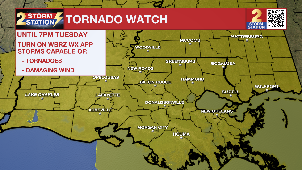
A TORNADO WATCH means conditions are favorable for tornadoes and/or damaging winds in and around the watch area. Be on the lookout for threatening weather conditions and listen for later statements and possible warnings. If a Tornado Warning is issued, seek shelter in a low-level, interior room of a sturdy building. Take pets (on a leash) with you, have on hard-soled shoes, monitor storm coverage on a wireless device, and cover your head in the event of wind or tornado impact. For more on tornado safety, CLICK HERE.
Primary threats include a few tornadoes likely with a couple intense tornadoes possible. Scattered damaging winds and isolated significant gusts to 80 mph likely. Isolated large hail events to 1 inch in diameter possible.
Remember that the WBRZ WX App. is *free* on Apple and Android devices and can be used for breaking weather information, live radar, and forecast details. You can also use it to watch live coverage if power or broadcast signal is ever lost. For even more, connect with the Storm Station on Twitter and Facebook. Stream WBRZ+ for continuous information as it becomes available.
Trending News
Click HERE to watch WBRZ streaming live online
Click HERE for the WBRZ weather page.
Click HERE to see how to download the WBRZ weather app.
Mardi Gras Day: High winds and storms on Mardi Gras Day may interrupt some outdoor activities. Have a way to receive weather alerts on Fat Tuesday as the impactful weather arrives in the Capital Region. Gusty winds will be felt by everyone, even outside of thunderstorms. Most will also experience storms during the afternoon, a few of which could be strong to severe. Temperatures will be mild all day with highs warming into the 70s ahead of the storms.
High Wind – Winds will continue to accelerate Tuesday morning and remain through the afternoon. A High Wind Warning has been issued across all of southern Louisiana. This alert is not as common, with the Capital Area averaging less than one per year. This emphasizes how much confidence there is in how much wind will be in the area. Sustained winds of 20 to 35 mph are likely with gusts to 45 mph. A few locations might see gusts as high as 60 mph, even outside of thunderstorms.

High-profile vehicles, including Mardi Gras floats, could become unstable if a gust of wind is caught. Travel for these vehicles will also be challenging. Damaging winds may blow down weak or dead trees, leading to scattered power outages.
Storms - Spotty morning showers will turn into widespread showers and thunderstorms during the afternoon. Storms will be in the Baton Rouge metro anywhere between Noon and 6 p.m., with the most likely arrival time in the early to mid-afternoon. These will pose problems for afternoon Mardi Gras parades, many of which have been rescheduled. The storms might also be on the strong to severe side. All severe hazards (wind, hail, tornadoes) are on the table. However, damaging straight-line winds and a few tornadoes appear to be the primary concerns. A Tornado Watch will be in effect for the Capital Area through the afternoon (see above).
Mardi Gras will be a day to stay weather-aware by having multiple ways of receiving weather alerts. One great way to be alerted immediately when severe weather threatens your neighborhood is the Storm Station Mobile App found HERE. Make sure notifications are turned on.
Rest of the Week: Conditions will quickly improve behind a cold front Tuesday night. Expect to wake up to clear skies Wednesday morning. The forecast will remain quiet and mild for Ash Wednesday activities and the second half of the workweek. The next rainmaker is set to arrive in the Capital Area over the weekend.
Get the latest 7-day forecast and real-time weather updates HERE.
Watch live news HERE.
– The Storm Station Meteorologists
The Storm Station is here for you, on every platform. Your weather updates can be found on News 2, wbrz.com, and the WBRZ WX App on your Apple or Android device. Follow WBRZ Weather on Facebook and X for even more weather updates while you are on the go.
More News
