

Latest Weather Blog
Late August weather pattern on repeat
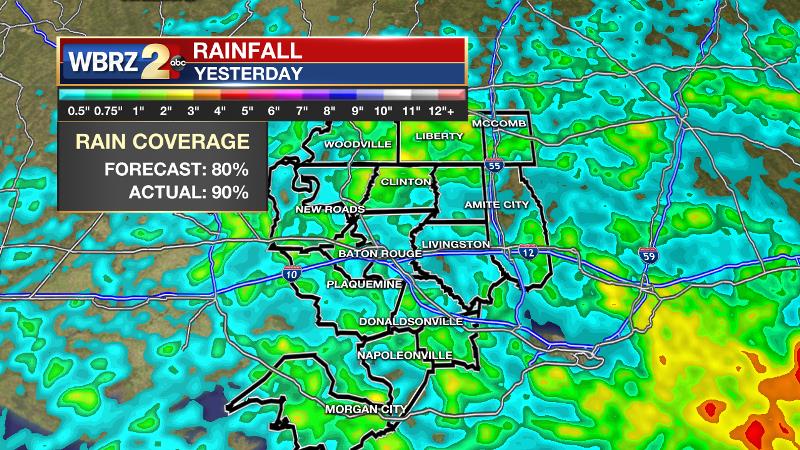
The routine will continue with morning showers and thunderstorms along the coast followed by afternoon showers and thunderstorms inland. Temperatures will be close to seasonal averages. Monday's forecast worked out as expected with almost everybody in the 13 Parish, 3 County forecast area receiving rainfall. Amounts stayed fairly manageable, just topping 3 inches in southwest Mississippi.
THE FORECAST:
Today and Tonight: Tuesday should see a slight decline in the number of showers and thunderstorms that develop across the area during afternoon. After some early sunshine, scattered action will break out by afternoon. Brief downpours are possible. High temperatures will be near 92 degrees and then low temperatures will be in the mid 70s as inland showers end overnight.
Up Next: Rain coverage will slowly tick back into the isolated category for the middle of the week, as an upper level ridge of high pressure over northern Mexico, will shift slightly east. By Friday, a weak disturbance in the Gulf of Mexico could develop and enhance rain coverage for the weekend. Overall, temperatures will be close to average for the time of year, with high temperature “busts” only occurring where rain cooling tamps warming.
Trending News
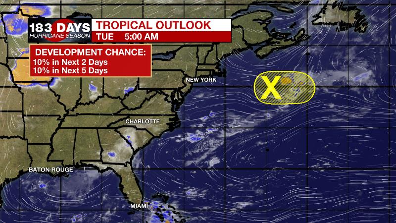
The Tropics: The Gulf of Mexico, Caribbean Sea and Atlantic Ocean are quiet. A weak disturbance east of New England is given a 10 percent chance of development as it races out to sea. With no named storms since Barry on July 15 through August 19, this is the first time that stretch has been named storm free since 1982, which was a historically inactive hurricane season. A large plume of Saharan dust across the eastern Atlantic has kept the favored development region very quiet.
THE EXPLANATION:
Efficient rainfall rates with scattered thunderstorms will be the main weather issue through the weekend. Adding to the threat for heavy rain, thunderstorms will be very slow moving. Fortunately, they will rain themselves out though. Either way, rainfall rates could cause a lot of water in a short time, which could overwhelm some drainage systems. A storm producing rainfall at a rate of 3 inches per hour could lead to flooding of low lying and poor drainage areas. By the end of the week, a shortwave trough of low pressure will move southeast across the Great Lakes and Northeast. This will pull an inverted upper level trough to the north across the Gulf of Mexico. The combination of these two features should not have significant impacts to the forecast area, but will maintain a moist summer pattern with elevated rain chances through the period. Through Sunday, the total rain forecast will be for 2 to 5 inches with localized higher amounts possible—mainly near the coast.
--Josh
The WBRZ Weather Team is here for you, on every platform. Your weather updates can be found on News 2, wbrz.com, and the WBRZ WX App. on Apple and Android devices. Follow WBRZ Weather on Facebook and Twitter for even more weather updates while you are on the go.
More News
