Saturday Morning Video Forecast
Related Story
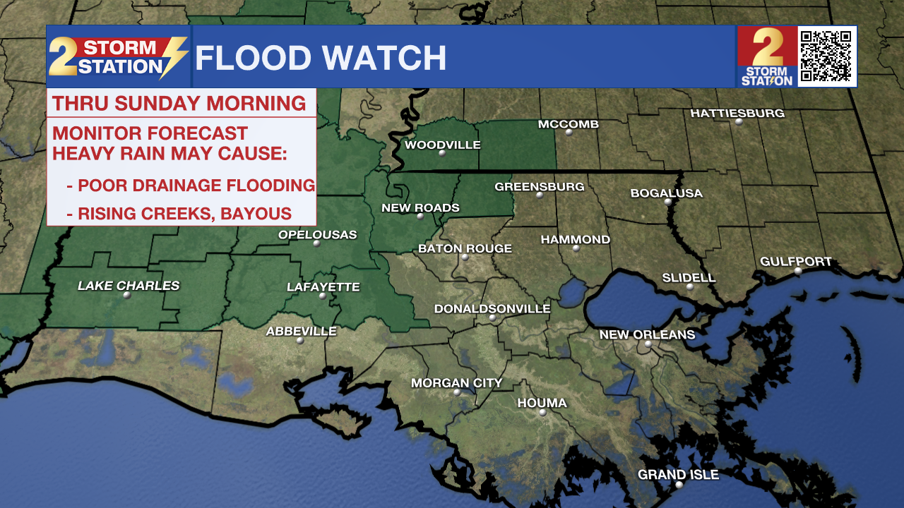
UPDATE - 1:50 p.m. Saturday: The National Weather Service has issued a FLOOD WATCH for East Feliciana, Pointe Coupee, and West Feliciana Parishes as well as, Amite and Wilkinson Counties through Sunday morning. An axis of heavy rain has already set up in central Louisiana and may clip the parishes listed above into the night. The potential is there for up to 2-4" of rain in the watch area. The Baton Rouge metro is purposefully not included in the watch as the majority of the rain should fall to the northwest. Storms are still possible in Baton Rouge on Saturday afternoon and evening, but on a more scattered basis. Rain gear is a good idea for any outdoor plans, including the LSU and Southern home games.

A FLOOD WATCH means conditions may develop that lead to flash flooding. Flash flooding is a very dangerous situation. Be on the lookout for threatening weather conditions and listen for later statements and possible warnings. For more on flooding safety, CLICK HERE.
ORIGINAL STORY: Game day in Baton Rouge will be warm, muggy, cloudy, and potentially rainy at times. For those heading out to tailgate or cheer on Southern or LSU today, bring your raingear and download the free Storm Station app to be notified when heavy rain or lightning is near your location.
Today: Overcast skies will stick around all day, limiting temperatures that begin in the 70s to only warm into the low and mid 80s. The same humid conditions that have been felt all week stick around today with an additional breeze out of the ESE between 10-20 mph continuing to allow Gulf moisture into the region. A front will approach the area from the west today, elevating rain chances, especially west of the Capital Area. Timing and exact location will be very important with this front, as it will control arrival time of any rain and who will see the most precipitation Saturday. The current forecast calls for rain chances to steadily increase as we go throughout the evening. Scattered showers and thunderstorms are expected, with the possibility for heavy downpours leading to localized flash flooding issues at times.
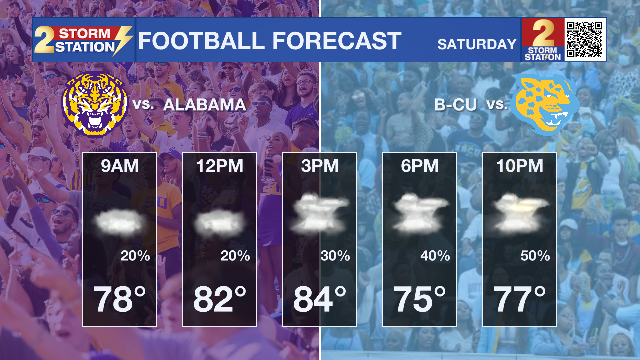
Football Forecast: It is a big weekend of college football with LSU and Southern both playing at home. Southern will kick off in muggy conditions, and temperatures in the 80's. Spotty showers will be around for the start of the game with rain chances increasing as the game goes on. The best chance of rain will likely hold off until the evening and late evening. LSU will kickoff with temperatures in the mid 70's. Rain will be more likely for this game. Timing for the best chance of rain depends on where exactly a weakening front sets up. Rain could arrive right when the game starts, or potentially hold off till the end of the game. The bottom line is rain will be a possibility during the game, so bringing a rain coat or a poncho is a safe bet.
According to the LSU Kickoff Weather Index, the Tigers have won over half of games played in the month of November at home with a kickoff temperature above 70°.

Up Next: The front will likely push through the state from west to east on Sunday, bringing scattered to numerous showers to all of southeast Louisiana overnight and into the first half of Sunday. This weak cold front will eventually clear the area on Monday afternoon, taking humidity levels down a notch as it goes. Temperatures will still remain warm with highs in the mid 80s to start the next week, but lower humidity will allow low temperatures to back into the mid 60s; cooler compared to recent days but still way above average.
The Storm Station has eyes on a more significant front that looks to pass through late in the week. This has a possibility of lowering highs into the 70's, and lows in the 50's as early as Thursday.
Get the latest 7-day forecast and real time weather updates HERE.
Watch live news HERE.
The Tropics: Rafael rapidly weakened on Friday evening, with maximum sustained wind speeds dropping 30 mph over 6 hours. That was enough for the storm to be downgraded to tropical storm status. This was expected as the storm interacted with lots of wind shear and ingested some dry air. Although the system will meander west and might briefly take a north turn, Rafael will eventually dive south into next week and fizzle out completely in the southern Gulf of Mexico.

- Emma Kate C.
The Storm Station is here for you, on every platform. Your weather updates can be found on News 2, wbrz.com, and the WBRZ WX App on your Apple or Android device. Follow WBRZ Weather on Facebook and Twitter for even more weather updates while you are on the go.


