Monday Midday Video Forecast
Related Story
In what has been a record-breaking warm start to November, we now have an unprecedented chance for a Tropical System to impact the forecast by late this week. Check back in with the Storm Station periodically over the next several days for the latest details.
Today & Tonight: Monday morning will start off over 20 degrees warmer than average for the beginning of November, with temperatures in the Capital City in the mid-70's. This is especially notable since the warmest low temperature on record for today (Nov. 4th) is 69°. An afternoon high in the upper-80s will also contend with records as the previous high for this date is 89° set back in 2016. To go along with the record warmth, winds will be breezy today, between 10-20 mph with gusts even higher. Skies will remain partly sunny throughout the day with a possible stray shower or two.
Overnight, expect the warm and muggy conditions to continue. Partly cloudy skies will limit temperatures to the lower-70s early Tuesday.
Up Next: As a cold front approaches but does not pass on Tuesday, we will see a slight uptick in rain chances across the area. The front should move close enough to support isolated shower and thunderstorm activity during the day Tuesday along with more cloud cover. By Wednesday, rain coverage will be limited again and afternoon highs will return to the upper-80s. Temperatures will remain unseasonably warm through the next week with the lack of a cold front passing through the region. It is not out of the question to see more records be challenged.
Another result of seeing no cold front arrive to the Capital Area this week is the opportunity for tropical activity to reach the region (see Tropics section below). As of Monday morning, there are a lot of uncertainties with the forecast past mid-week. At this point, the long-term track of what will soon become Rafael holds higher uncertainty than normal. Stay tuned to the latest forecast this week, as adjustments may or may not be needed closer to the weekend depending on the future track of Rafael. For now, the Storm Station 7-Day Forecast keeps things quiet into the weekend.
Get the latest 7-day forecast and real time weather updates HERE.
Watch live news HERE.
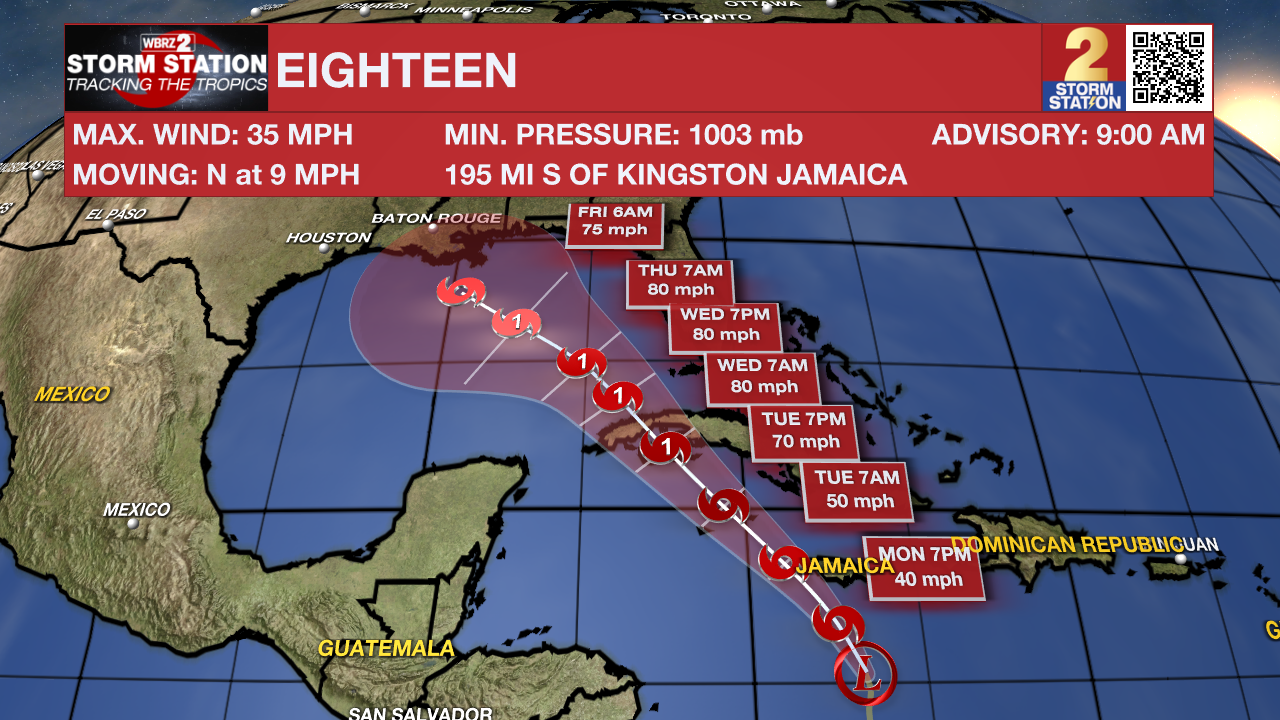
The Tropics: The National Hurricane Center began issuing advisories for now Tropical Depression Eighteen on Sunday afternoon. Eighteen will likely become a tropical storm on Monday and will take the name Rafael. The latest forecast has the storm reaching hurricane strength as it approaches Cuba. The storm is then projected to move northwestward into the Gulf of Mexico around midweek.
After moving into the Gulf, the steering currents rearrange in a fashion that could allow the system to slow down and meander temporarily. This introduces significant uncertainties to the long-term track forecasts. It is still too far out to know if and where impacts may set up along the Gulf Coast. From an intensity standpoint, the storm will encounter a more hostile environment in the Gulf which would limit additional strengthening.
It is worth noting that Louisiana has never experienced a landfall by a named system in the month of November. Should that occur, it would be unprecedented. But with a lack of cold fronts cleanly passing through to help shield the region from the system in the coming days, it is worth monitoring.

Meanwhile, another area of disturbed weather could develop near the northern Leeward Islands around the middle of the week. Slow development is possible thereafter as it moves generally westward over the southwestern Atlantic.
- Emma Kate C.
The Storm Station is here for you, on every platform. Your weather updates can be found on News 2, wbrz.com, and the WBRZ WX App on your Apple or Android device. Follow WBRZ Weather on Facebook and Twitter for even more weather updates while you are on the go.


