

Latest Weather Blog
Tuesday PM Forecast: warming and quiet pattern ahead of weekend storm system
Expect the warming trend and mostly dry conditions to continue across the Capital Area. The chance for rain and thunderstorms, as well as severe weather, will increase heading into the weekend.
Tonight & Tomorrow: High pressure will dominate the region, keeping skies clear and temperatures comfortable. Tonight will be cool, with lows dipping into the upper 40s to low 50s. Plenty more sunshine is ahead on Wednesday with just a few high clouds mixing into skies late. Look for highs in the upper 70s, possibly hitting 80°F in some spots.
Up Next: The end of the week will be even warmer, with breezy conditions at times. Thursday will see a slight uptick in high temperatures, climbing to the mid-80s. A stray rain shower is possible as early as a moisture-starved disturbance moves through the atmosphere. Most will just notice a few extra passing clouds. By Friday, a stronger disturbance will move into the Midwest, with the local area finding increasing south winds of 10-15mph, more cloud cover, and a slightly better chance for a spotty shower or thunderstorm. Still, do not expect any major impact to outdoor activities; the real action arrives over the weekend.
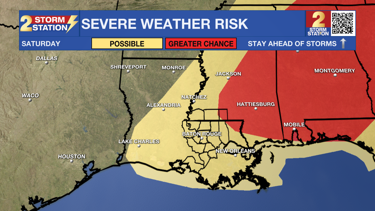
Saturday: A strong storm system will move in, bringing in more widespread rain and thunderstorms and, perhaps more notably, the possibility of severe weather. Both energy and winds in the atmosphere will increase, meaning we could see strong thunderstorms with all hazards such as wind, hail, and isolated tornadoes possible. While ingredients look supportive for strong storms areawide, the spots to really hone in on will be north and east of Baton Rouge. The timing will be important to outdoor events such as the Wearin’ of the Green Parade, however, those details will not become clear until around Thursday.
Trending News
Beyond: After the storms move out, Sunday and Monday will be much calmer. Highs will ease back into the upper 70s, with lows dipping into the upper 40s to low 50s. Just a few clouds may linger on Sunday, but expect mostly sunny skies to start the new workweek.
Get the latest 7-day forecast and real-time weather updates HERE.
Watch live news HERE.
– Josh
The Storm Station is here for you, on every platform. Your weather updates can be found on News 2, wbrz.com, and the WBRZ WX App on your Apple or Android device. Follow WBRZ Weather on Facebook and X for even more weather updates while you are on the go.
More News
