

Latest Weather Blog
Monday AM Forecast: High winds and strong storms could impact Fat Tuesday activities
High winds and storms on Mardi Gras Day may interrupt some if not all outdoor activities. Have a way to receive weather alerts on Tuesday as the impactful weather arrives in the Capital Region.
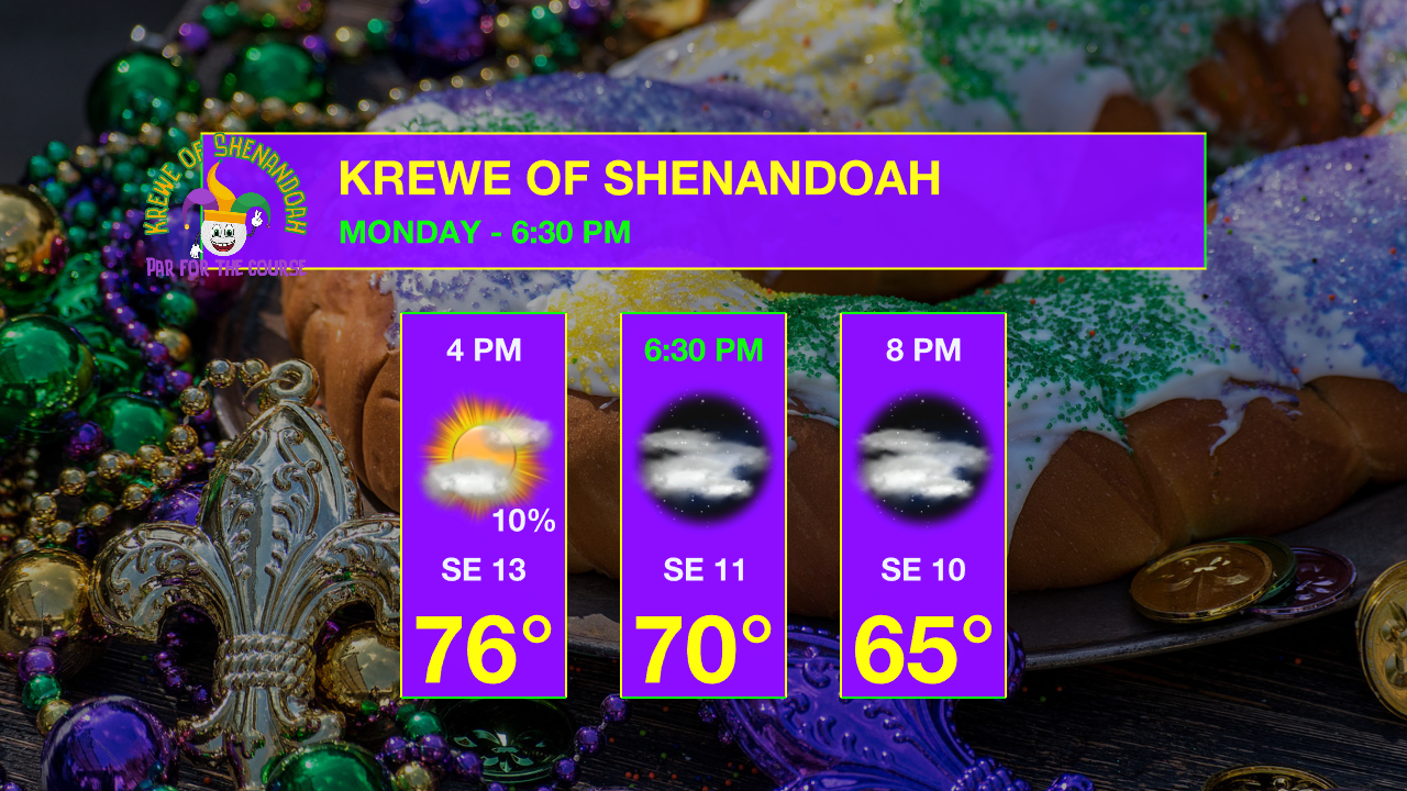
Today & Tonight: Monday will start off cool with lows in the 40s and warm into the middle 70s under a mix of sun and clouds. One or two stray showers may develop but overall conditions will remain dry for Lundi Gras parades. Winds will gradually increase throughout the day, becoming noticeably breezy, out of the southeast anywhere from 7-17 mph, by Monday afternoon. The ramp-up in wind speeds will continue overnight and into Mardi Gras as a storm system arrives. Lows tonight will only fall near 60 degrees in Baton Rouge.
Mardi Gras – Next Impact: The two big weather stories on Mardi Gras will be wind and storms. Gusty winds will be felt by everyone, even outside of thunderstorms. Most will also experience storms at some point, a few of which could be strong to severe.
Wind - A High Wind Watch has been issued for Mardi Gras across all of southern Louisiana. The associated bulletin notes the potential for 30-40 mph winds with gusts to 60 mph. This might be a touch overdone but is a reasonable worst-case scenario. Sustained winds of 20-30 mph with gusts in the 40+ range seem very likely – which is windy in and of its own right. These winds will occur within and outside of thunderstorms.
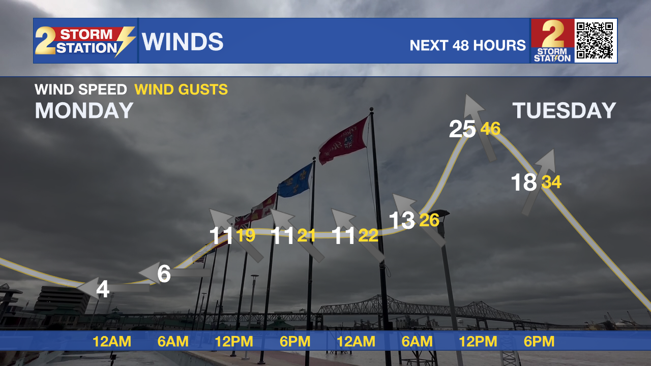
High-profile vehicles, including Mardi Gras floats, could become unstable if a gust of wind is caught. Similarly, travel for high-profile vehicles could be difficult. Isolated to scattered power outages are also possible.
Trending News
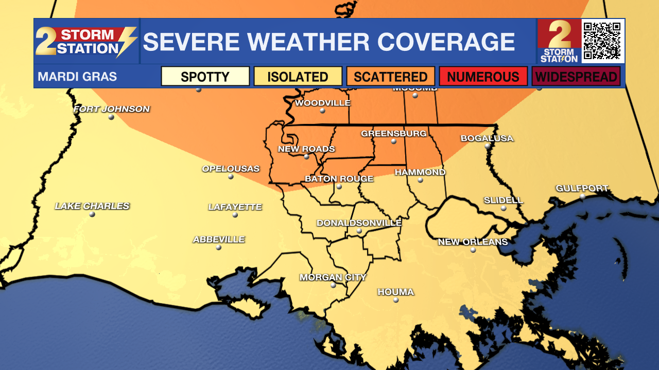
Storms - Spotty morning showers will turn into widespread showers and thunderstorms during the afternoon. Lightning will pose problems for afternoon Mardi Gras parades, with morning parades having the best chance of avoiding these concerns. In addition, the afternoon storms could be on the strong to severe side. An “Enhanced” Level (3/5) risk of severe weather has been issued for areas north of I-12, with a “Slight” Level (2/5) risk for areas south. While not everybody will experience severe weather, isolated point locations could – especially north of the interstate. All severe hazards (wind, hail, tornadoes) are on the table.
Mardi Gras will be a day to stay weather-aware by having multiple ways of receiving weather alerts. One great way to be alerted immediately when severe weather threatens your neighborhood is the Storm Station Mobile App found HERE. Make sure notifications are turned on.
Rest of the Week: Conditions will quickly improve behind a cold front Tuesday night. Expect to wake up to clear skies Wednesday morning. The forecast will remain quiet and mild for Ash Wednesday activities and the second half of the workweek. The next rainmaker is set to arrive in the Capital Area over the weekend.
Get the latest 7-day forecast and real-time weather updates HERE.
Watch live news HERE.
– The Storm Station Meteorologists
The Storm Station is here for you, on every platform. Your weather updates can be found on News 2, wbrz.com, and the WBRZ WX App on your Apple or Android device. Follow WBRZ Weather on Facebook and X for even more weather updates while you are on the go.
More News
