

Latest Weather Blog
Heightened Rain Chances Through the Week
THE FORECAST:
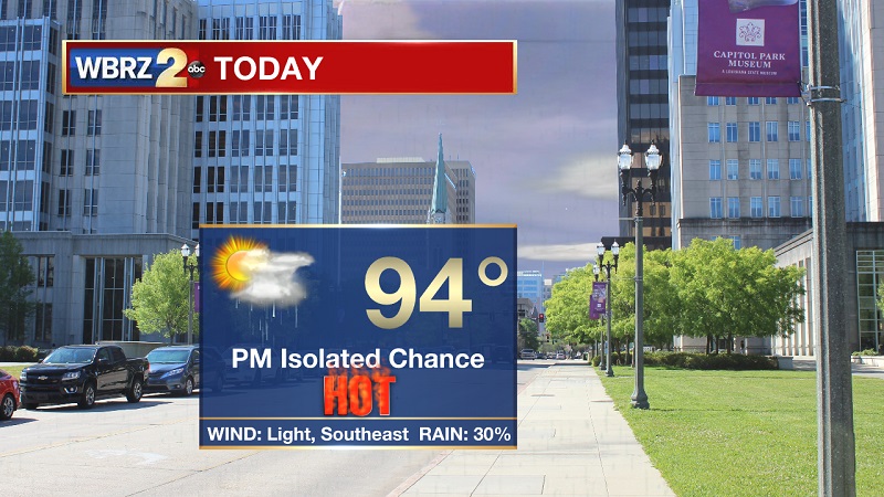
Today and Tonight: A ridge of high pressure stays put as we head into Monday, keeping hot conditions around. A stationary front will approach from the north as well as southerly winds, which will increase spotty to isolated chances through the afternoon and evening hours. Temperatures will reach into the 90s around 11 AM, as highs peak near 94° and heat index values around 106°. Winds will stay light out of the southeast, and calming tonight. Some pockets of showers will linger until 8 PM, mostly to our north. Overnight lows will drop near 74° into Tuesday morning.
Up Next: Spotty to isolated showers and storms through much of the week, as highs stay in the low to mid-90s. Rain chances increase over the weekend, as highs approach 90° Sunday.
The Tropics:
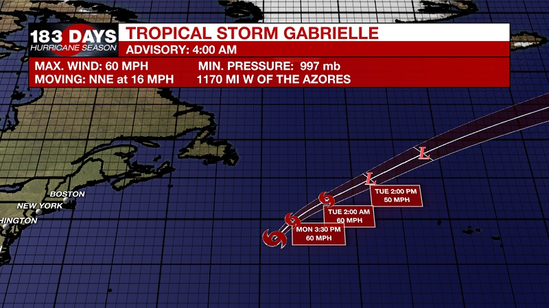
Tropical Storm Gabrielle is currently located about 1170 miles west of the Azores with 60 mph sustained winds and moving north-northeast at 16 mph. A turn toward the northeast with an increase in forward speed is expected today, and a northeastward motion at an even faster forward speed is expected on Tuesday and Wednesday. Little change in strength is expected today, but a weakening trend is likely to begin tonight. Gabrielle is expected to become an extratropical low by Tuesday night.
Trending News
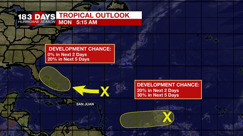
We are also tracking two tropical waves.
The first is a broad area of low pressure that is producing showers and storms about midway between the Cabo Verde Islands and the Windward Islands. Some slow development of this system is possible during the next few days before upper-level winds become unfavorable for tropical cyclone formation. This system is expected to move generally westward across the tropical Atlantic Ocean during the next several days. The National Hurricane center is forecasting a 20% chance of tropical development within the next 2 days, which increases to a 30% chance within the next 5 days.
The second is an area of disorganized showers and storms that is located a few hundred miles north and northeast of the northern Leeward Islands and is associated with a surface trough interacting with an upper-level low. Strong upper-level winds are expected to prevent the development of this system during the next few days while it moves west-northwestward to the north of the Leeward Islands and Puerto Rico. However, environmental conditions could become a little more favorable for development when the disturbance moves near the Bahamas and Florida late this week. The National Hurricane center is forecasting a 0% chance of tropical development within the next 2 days, which increases to a 20% chance within the next 5 days.
THE EXPLANATION:
A ridge of high pressure stays put as we head into Monday, keeping hot conditions around. A stationary front will approach from the north, increasing spotty to isolated chances through the afternoon and evening. The stationary front will stall in northern Louisiana and central Mississippi, keeping the majority of storm activity slightly to our north today before lifting toward the northeast on Tuesday. While this occurs, the ridge will shift back to the northwest, incorporating most of the southeast US. This will allow for the surface Bermuda high to again infiltrate into the eastern Gulf of Mexico, bringing a return to light onshore flow from the Gulf. This will increase afternoon rain chances through much of the week. Guidance is suggesting a tropical wave will push in as we near the weekend, helping to bump up rain chances and coverage beginning Saturday. High temperatures should finally drop to below average, which would be the first time since August 26th.
--Meteorologist Matt Callihan
The WBRZ Weather Team is here for you, on every platform. Your weather updates can be found on News 2, and the WBRZ WX App. on Apple and Android devices. Follow WBRZ Weather on Facebook and Twitter for even more weather updates while you are on the go.
More News
