

Latest Weather Blog
Friday AM Forecast: Tracking weekend showers and thunderstorms
Numerous showers and thunderstorms will roll through the Capital Area over the next several days and could impact outdoor plans, including LSU Baseball games. Keep raingear handy this weekend and don't forget to check the Storm Station Weather App's radar before heading outside!
Here’s a breakdown of what to expect:
- Friday night into Saturday morning: Off and on heavy rain and spotty strong thunderstorm
- Saturday afternoon & evening: Gradual clearing
- Sunday: Mostly dry and warm—best day for outdoor plans
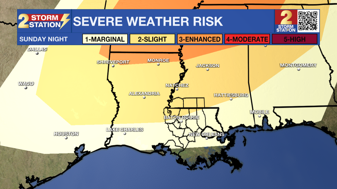
- Sunday night into Monday: Another round of storms, possibly strong
- Tuesday to Thursday: Warming up, mostly dry, becoming breezy
Friday & Saturday: Friday will be mild, cloudy and breezy ahead of incoming rain. Isolated showers and storms will begin to move into southeast Louisiana this afternoon, with an increase in rain coverage overnight. There will be dry periods this evening so if you have Friday night dinner plans or are heading out to Alex Box Stadium, keep raingear handy and monitor the changing conditions. Within these passing storms, heavy downpours, gusty winds and lots of lightning are possible. Thunderstorms will continue to roll through the region overnight and into Saturday. By Saturday afternoon, around 1-3" of rainfall is expected to accumulate, with isolated areas receiving more. The system will clear from west to east tomorrow afternoon with drier conditions taking over by Saturday evening.
Sunday: Sunday will be the better of the two weekend days to get outside and enjoy the warm Spring weather. A spotty shower or storm cannot be completely ruled out, but overall the day will see a mix of sun and clouds with warm afternoon highs in the mid-80s.
Trending News
Next Week: Another rainmaker will move towards the Capital Area late Sunday into Monday. This round of storms will be triggered by a cold front approaching from the northwest. As the front nears, a line of stronger storms could produce more heavy rain, gusty winds, and even an isolated tornado. Monday morning’s commute could be tricky, so plan accordingly.
By Monday afternoon, quieter conditions will return. Tuesday, April 1st, looks sunny with highs in the mid-80s, while Wednesday and Thursday will be even warmer, climbing into the upper 80s. The next front will arrive toward the end of next week.
Get the latest 7-day forecast and real-time weather updates HERE.
Watch live news HERE.
– Emma Kate C.
The Storm Station is here for you, on every platform. Your weather updates can be found on News 2, wbrz.com, and the WBRZ WX App on your Apple or Android device. Follow WBRZ Weather on Facebook and X for even more weather updates while you are on the go.
More News
