

Latest Weather Blog
Wednesday AM Forecast: Possible record warmth to end the week, Cold front brings changes Sunday
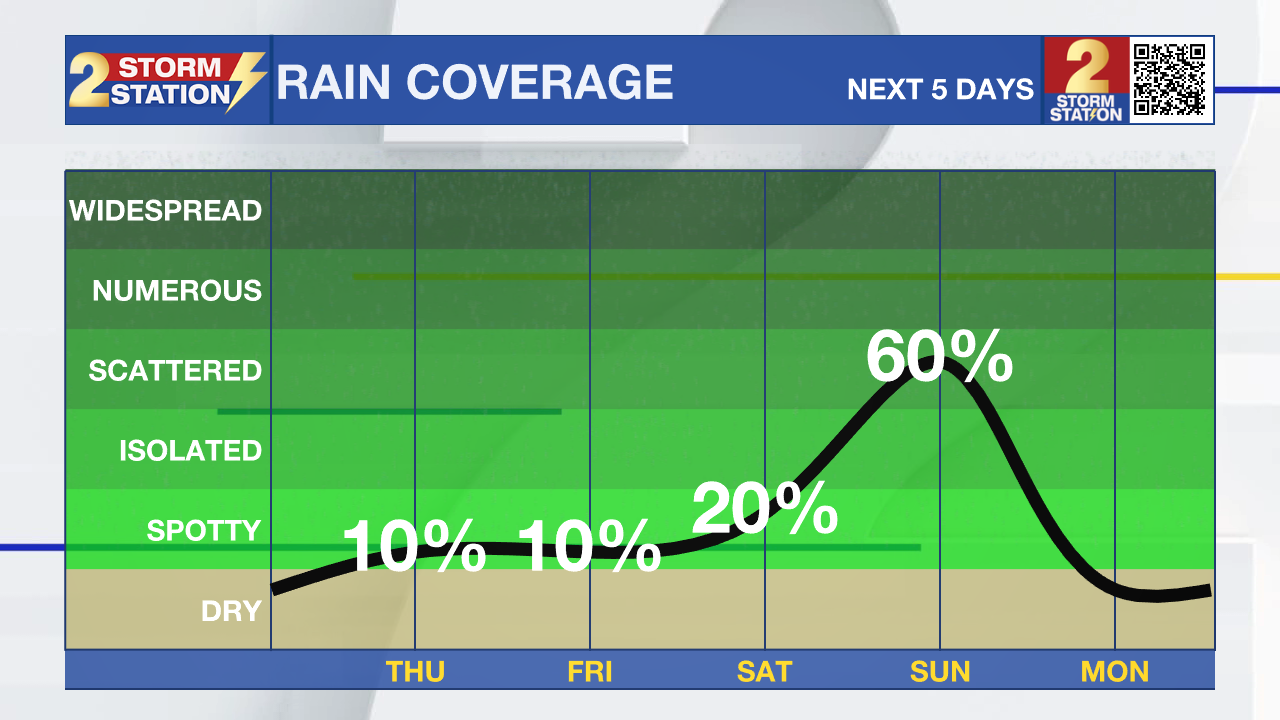
The unseasonably warm and muggy weather continues to trek on. We won't see any drop in temperatures or humidity levels until a cold front arrives this weekend, brining with it our greatest chance of rain for the week.
Today & Tonight: Overcast conditions for the majority of the day Wednesday doesn't have much, if any, effect on temperatures. With the additional clouds around today, expect similar lows and highs as Tuesday. Temperatures that will start off between the upper-60's and low 70's this morning will warm back near 86° this afternoon in Baton Rouge. Increased humidity levels continue to give a "sticky" feel to the air. Unlike Tuesday, winds around the state should not be as gusty, but we will keep a light breeze out of the south between 10-15 mph.
Overnight, expect much of the same as cloudy skies only allow temperatures to fall near 71° for Thursday morning lows.
Up Next: Thursday will feature mainly cloudy skies with a few breaks of sun, while Friday could see the most sunshine over the next several days. Both days to conclude the workweek will see afternoon temperatures in the upper-80's. Depending on the amount of sunshine we get Friday, it's not out of the question for the Capital Area to hit or exceed the 90° mark, which would meet or beat the record high of 90° for April 19th set back in 2006 and 1987. While most will continue to stay dry to end the week, a nuisance shower or two could pop up either day.
Trending News
Saturday will be the final day of warm and muggy conditions for this week as a cold front brings relief late that evening and into Sunday. As the front arrives from the NW, we will see a gradual increase in shower and storm activity, some as early as Saturday evening. We expect the majority of rain to fall on Sunday, which will keep temperatures significantly cooler, in the mid-70s. No severe weather is expected with this system. By Monday, northerly winds behind the front will send dew points down and temperatures back into the 70's for the day. We will also welcome back the sunshine to start off the new workweek.
Get the latest 7-day forecast and real time weather updates HERE.
Watch live news HERE.
– Emma Kate Cowan
The Storm Station is here for you, on every platform. Your weather updates can be found on News 2, wbrz.com, and the WBRZ WX App on your Apple or Android device. Follow WBRZ Weather on Facebook and Twitter for even more weather updates while you are on the go.
More News
