

Latest Weather Blog
Tuesday AM Forecast: Temperatures & humidity increase ahead of next impact
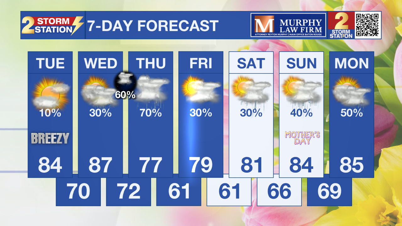
Get ready for a sticky middle of the workweek as temperatures and humidity levels quickly increase. This will be ahead of a cold front that will bring storms, and even a low-end severe weather threat.
Today & Tonight: Expect a bit of a breeze today as southeasterly winds will be sustained between 10 and 20 mph with gust up to 25 mph. These southerly winds will bring in higher moisture content and also warmer air from the northern Gulf. This will cause afternoon highs to reach into the mid-80s, and the air to feel muggy. A few stray showers will be possible but the overwhelming vast majority will stay dry. Overnight, lows come up even more, near 70 degrees.
Up Next: Wednesday will bring building heat and climbing humidity, with afternoon highs reaching the upper 80s and moisture levels reminiscent of mid-summer. While a stray, heat-driven pop-up shower is possible during the day, most of the activity will hold off until a cold front nears the region after dark. This weakening line of storms is expected to reach the I-10/I-12 corridor late Wednesday night into the pre-dawn hours of Thursday. Although the primary risk for severe weather remains well to our north and west, we cannot entirely rule out a spotty strong storm as the system moves through.
The forecast for Thursday hinges on the exact positioning of the cold front as it settles over the Capital Area. Daytime heating will likely trigger more storm development, though rain coverage—currently at 70%—may be adjusted downward if recent trends toward a drier solution continue. This increased cloud cover and precipitation will provide a reprieve from the heat, keeping temperatures in the 70s. However, we remain weather-aware as a few storms could become strong to severe. Additionally, because these storms may move repeatedly over the same areas, we are monitoring the potential for heavy rainfall that could lead to localized street flooding.

Mother’s Day Weekend: The weekend forecast is finally gaining some clarity, though the specific details depend entirely on the movement of the midweek frontal system. As this front pushes toward the coast on Friday, it may generate isolated showers, with the highest concentration expected along and south of the I-10 corridor. By Saturday, the boundary is projected to settle just offshore, remaining close enough to keep a few showers in the forecast for the start of the weekend. A more significant transition occurs on Mother’s Day as the front begins to retreat northward as a warm front. This shift will open the door for a surge in Gulf moisture, leading to a noticeable increase in both heat and humidity across the region. Consequently, the atmosphere will become more unstable, resulting in a higher likelihood of thunderstorms to round out the holiday weekend.
Trending News
Get the latest 7-day forecast and real-time weather updates HERE.
Watch live news HERE.
– Balin
The Storm Station is here for you, on every platform. Your weather updates can be found on News 2, wbrz.com, and the WBRZ WX App on your Apple or Android device. Follow WBRZ Weather on Facebook and X for even more weather updates while you are on the go.
More News
