

Latest Weather Blog
Heavy thunderstorms to start off the morning, severe weather threat remains
An approaching cold front will bring periods of rain and thunderstorms to the Capital Area through Saturday afternoon. Some of the storms could be heavy and strong. Much cooler air will follow.

Today & Tonight: Thunderstorm activity has blossomed across the area this morning, with some of these producing heavy rainfall. Some locations already have estimated totals near 2" and more is on the way. Throughout the course of the day, widespread showers and thunderstorms are expected. Rain won't be everywhere at one time, but just about everyone will see at least one round of storms. Repeating rounds of heavy rain in localized areas could lead to flash flooding, which is why a Flood Watch has been issued for much of the area. There is also a risk of strong to severe storms, and there is more on that written below. Storms will remain likely until a cold front sweeps through Saturday morning.
Trending News

Use the slider to advance through the next 24 hours of Futurecast
The National Weather Service has issued a Flood Watch for East Baton Rouge, West Baton Rouge, Ascension, Assumption, Iberville, East Feliciana, Livingston, St. Helena, St. James, and Tangipahoa Parishes, as well as Amite County, from Midnight Friday through 9 a.m. Saturday. A Flood Watch means conditions may develop that lead to flash flooding. Flash flooding is a very dangerous situation. Be on the lookout for threatening weather conditions and listen for later statements and possible warnings. For more on flooding safety, CLICK HERE.
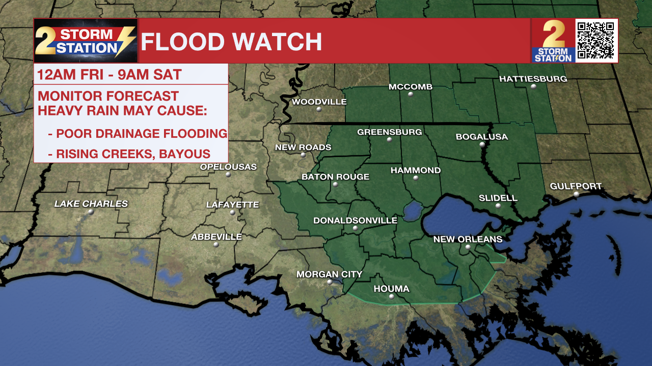
Rainfall totaling 1-2" is likely as a baseline, but localized areas could see on the order of 3-5"+. In the areas that see particularly high rain amounts, excessive runoff may result in flooding of rivers, creeks, streams, and other low-lying and flood-prone locations. Flooding may occur in poor drainage and urban areas. The localized flooding threat is in addition to the threat of strong to severe thunderstorms discussed in the forecast below.
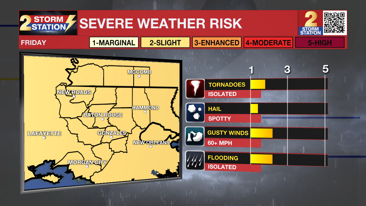
A strong storm or two cannot be ruled out during the morning, but chances of coming across one will increase with daytime warming. By no means is this a "slam dunk" severe weather threat, but the ingredients will be in place for severe weather, so it's best to keep an eye out for weather alerts and be prepared to take action. The Storm Prediction Center has issued a Level 2/5 "Slight" risk of severe weather for the entire area, indicating the potential for isolated severe weather. The afternoon and evening appear to be the prime window for it. Severe storms would be capable of damaging straight-line winds, isolated tornadoes, and embedded hail.

Up Next: Showers and storms will remain a possibility until a cold front crawls through the area early on Saturday. Once it passes, rain chances will slowly diminish despite lingering clouds. A cooldown will follow, with highs not leaving the 60s on Saturday and the 50s on Sunday. Sunshine finally starts to return early next week, and temperatures will be below average. Expect highs in the 50s, with lows near freezing. Clouds start to move in again on Tuesday with comfortably cool conditions persisting.
Remember that the WBRZ WX App. is *free* on Apple and Android devices and can be used for breaking weather information, live radar, and forecast details. You can also use it to watch live coverage if power or broadcast signal is ever lost. For even more, connect with the Storm Station on X and Facebook. Stream WBRZ+ for continuous information as it becomes available.
— The Storm Station Meteorologists
The Storm Station is here for you, on every platform. Your weather updates can be found on News 2, wbrz.com, and the WBRZ WX App on your Apple or Android device. Follow WBRZ Weather on Facebook and X for even more weather updates while you are on the go.
More News
