

Latest Weather Blog
Monday AM Forecast: Jackets needed early, no layers in the afternoon
It is another morning with chilly temperatures across the area so grab a jacket! We will warm out of jacket territory throughout the day, which means you can eventually shed those layers. This will be a theme for the rest of the week.
Today & Tonight: After the chilly start, you can start to shed those layers by 10-11am. Highs will be comfortable, in the upper 70s. Sunshine will dominate all day long, with a few higher level clouds filtering the sunshine at times. Clouds will thicken overnight, increasing lows to the low to mid-50s. Jackets will still be a good idea.

Up Next: Temperatures will gradually moderate throughout the week, holding near or slightly below seasonal averages. Morning lows will remain cool, dropping into the 50s, before warming into the 80s by the afternoon. Skies will stay predominantly sunny, with only occasional high cloud cover. Despite the cooler fall conditions, UV radiation remains elevated, making sun protection a good idea. No measurable precipitation is expected over the next seven days. With local drought conditions worsening, dry vegetation presents a heightened risk for grass fires. Exercise strict caution with any outdoor burning or potential ignition sources, regardless of whether a formal Red Flag Warning is in effect.
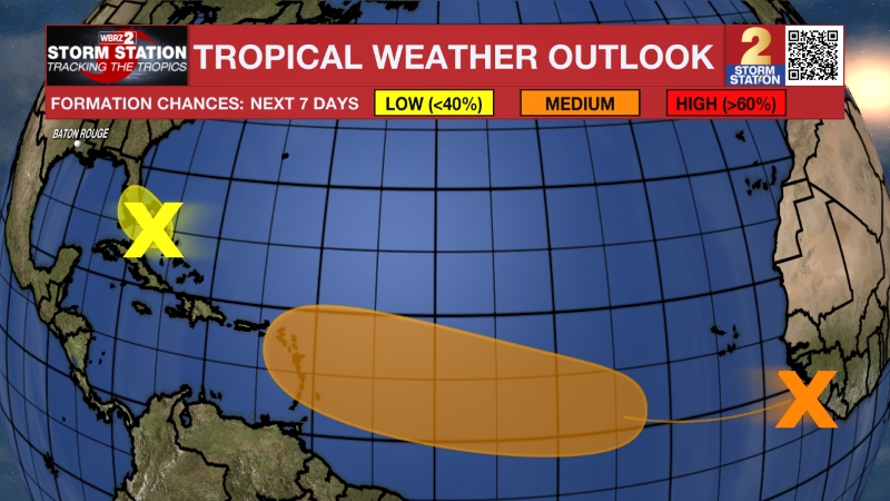
The Tropics: A storm-force non-tropical low pressure area is located along a frontal boundary a few hundred miles off the southeast coast of the United States. This low is likely to move slowly and erratically over the next couple of days, and it could gradually acquire subtropical characteristics if it remains over the Gulf Stream. A subtropical cyclone could form during the middle to latter portions of the week when the system begins to move northeastward away from
the eastern United States. Environmental conditions are expected to become unfavorable for development by the weekend. Regardless of the system's status, high winds, coastal flooding, and dangerous surf are expected along portions of the U.S. East Coast during the next few days.
Trending News
Get the latest 7-day forecast and real-time weather updates HERE.
Watch live news HERE.
— Balin
The Storm Station is here for you, on every platform. Your weather updates can be found on News 2, wbrz.com, and the WBRZ WX App on your Apple or Android device. Follow WBRZ Weather on Facebook and X for even more weather updates while you are on the go.
More News

