

Latest Weather Blog
El Nino has arrived: quieter hurricane season expected, but there's a catch
It’s official: El Niño has formed in the central Pacific, according to the Climate Prediction Center. This is just the beginning, as El Niño is projected to intensify over the coming months, likely impacting hurricane season and altering global weather patterns.
Forecasts indicate a high probability of a strong event, with a 68% chance of it materializing by the peak of hurricane season, followed by a 63% chance of a very strong, potentially record-breaking event by early winter.
How El Niño Tames The Tropics:
This is a story the Storm Station has been tracking for months. As a quick refresher, El Niño is a massive pool of abnormally warm water that sits right along the equator in the eastern Pacific. This creates a region of stormy weather in the Pacific, which kicks off a chain reaction. El Niño first enhances the subtropical jet stream, a band of high winds in the upper atmosphere that blows into the tropical Atlantic, boosting wind shear that rips apart developing tropical systems.
This creates a hotspot of stormy weather in the Pacific that kicks off a massive global chain reaction. The process enhances the subtropical jet stream, a band of high-speed winds in the upper atmosphere that blows into the Atlantic, ramping up the wind shear that rips apart developing tropical systems. The subtropical jet also has a tendency to sink over the Caribbean and tropical Atlantic, working against thunderstorms required to feed a hurricane.
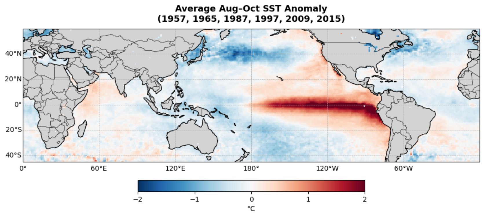
History Agrees: Citing El Niño as the dominant factor, Colorado State University lowered its 2026 Atlantic hurricane forecast with its June update. The updated report notes that current ocean temperatures and atmospheric conditions closely resemble those of 1957, 1965, 1987, 1997, 2009, and 2015.
Trending News
Average sea surface temperatures relative to average from August-October in 1957, 1965, 1987, 1997, 2009, and 2015
El Niño had fully developed in each of those years by the peak of hurricane season, and each season brought below-average hurricane season activity:
| Year | Named Storms (Average: 14) |
Hurricanes (Average: 7) |
Major Hurricanes (Average: 3) |
| 1957 | 8 | 3 | 2 |
| 1965 | 10 | 4 | 1 |
| 1987 | 7 | 3 | 1 |
| 1997 | 8 | 3 | 1 |
| 2009 | 9 | 3 | 2 |
| 2015 | 11 | 4 | 2 |
Still, It Only Takes One Storm: While forecast data, current observations, and historical analogs provide a clear outlook for lower overall storm numbers in 2026, these seasonal predictions say nothing about where individual tracks will lead or who they will ultimately impact.
There have been many significant storms even in the “quiet” years of 1957, 1965, 1987, 1997, 2009, and 2015, including some in Louisiana:
• 1957 – Hurricane Audrey made landfall in southwest Louisiana as a strong Category 3 storm, causing $150 million in damage and killing 416. Four other tropical storms made landfall along the U.S. Gulf Coast that year.
• 1965 – Hurricane Betsy unleashed fury in Louisiana, making landfall as a Category 4 hurricane. Storm surge from Betsy inundated New Orleans’ levee system, flooding much of the city. Betsy had a death toll of 81 with economic damages exceeding $1 billion. Three other tropical storms made landfall along the U.S. Gulf Coast that year.
• 1987 – No major hurricanes made landfall in 1987, though Hurricane Emily did make landfall in the Dominican Republic and Bermuda as a Category 2 and 1, respectively. One other weak tropical storm made landfall in Texas early in the season.
• 1997 – Hurricane Danny made landfall near Buras as a Category 1 hurricane in July, then continued northeast to make further landfalls in Alabama as a weak hurricane. Danny is remembered for extreme rainfall totals and a tornado outbreak across the Southeast U.S.
• 2009 – Tropical Storm Claudette made landfall on Santa Rosa Island in the Florida Panhandle as a tropical storm. Later that November, Hurricane Ida narrowly missed a Louisiana landfall, tracking just east of the mouth of the Mississippi River before pushing toward Alabama. Notably, this 2009 storm is entirely distinct from the catastrophic Category 4 Hurricane Ida that struck southeast Louisiana in 2021.
• 2015 – Tropical Storm Ana and Bill were the only storms to make landfall in the U.S., doing so in May and June, respectively. The only other noteworthy storm is Hurricane Joaquin, which battered the Bahamas over a span of multiple days. Joaquin’s name was retired from use in the list of hurricane names due to the destruction it left behind.
These storms emphasize that even a slow year on paper can still have catastrophic impacts with the right storm placement. For more on the season ahead and preparedness, visit the Hurricane Center.
The Storm Station is here for you, on every platform. Your weather updates can be found on News 2, wbrz.com, and the WBRZ WX App on your Apple or Android device. Follow WBRZ Weather on Facebook and X for even more weather updates while you are on the go.
More News
