

Latest Weather Blog
Monday Morning Forecast
Related Story
Expect more showers and thunderstorms again this afternoon.
THE FORECAST
Today & Tonight: Monday morning muggies are back! Waking up to some leftover clouds and moisture from the showers yesterday. Temperatures will rise into the low 90s today. Most people will see some rain today. Localized heavy downpours are expected as these showers and thunderstorms move through the area. Rain and cloud cover will linger into the overnight hours. Temperatures will cool into the mid-70s. The humidity will be sticking around for Tuesday morning.
Up Next: Tuesday the pattern repeats. We will be waking up to temperatures in the mid-70s and plenty of moisture leaving us feeling sticky. Partly sunny skies will only allow for temperatures to heat into the low-90s. Showers will be sneaking in during the afternoon hours. Showers and thunderstorms are expected during the evening commute. Clouds and some showers will linger overnight. Wednesday the pattern continues. We are getting into a more summertime-like pattern where temperatures stay in the low-90s and cool-down showers move through during the afternoon hours.
Click here to see the 7-day forecast.
Hour-by-hour weather tracking is available for your location on the WBRZ WX App on your Apple or Android device. Follow WBRZ Weather on Facebook and Twitter for even more weather updates and unique weather insight from the whole team!
In the Tropics:
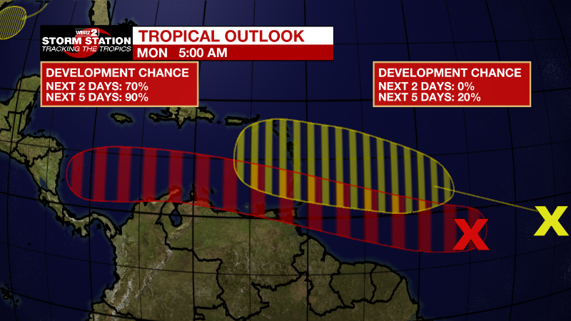
Central Tropical Atlantic:
Shower and thunderstorm activity has increased in association with a
tropical wave located about 950 miles east-southeast of the southern
Windward Islands. Environmental conditions appear conducive for
further development, and a tropical depression is likely to form
during the next couple of days before the system reaches the
Windward Islands Tuesday night or possibly while moving westward
across the southern Caribbean Sea Wednesday through Friday. A NOAA
Hurricane Hunter aircraft is scheduled to investigate the system
this afternoon. Interests in the Windward Islands and along the
northeastern coast of Venezuela should monitor the progress of this
system, and tropical storm watches or warnings could be required for
portions of these areas later today. Regardless of development,
locally heavy rainfall is possible over the Windward Islands and the
northeastern coast of Venezuela Tuesday night and Wednesday.
* Formation chance through 48 hours...high...70 percent.
* Formation chance through 5 days...high...90 percent.
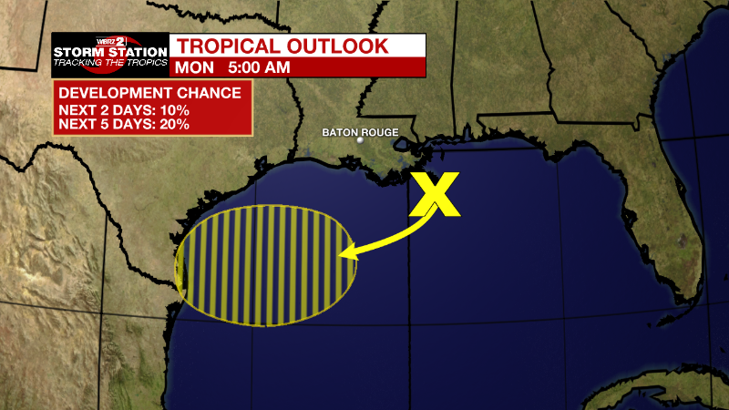
Northern Gulf of Mexico:
Disorganized showers and thunderstorms over the north-central and
northeastern Gulf of Mexico are associated with a trough of low
pressure. Development of this system is expected to be slow to
occur while it moves west-southwestward at about 10 mph toward the
northwestern Gulf of Mexico and approaches the coasts of southern
Texas and northeastern Mexico during the next few days.
* Formation chance through 48 hours...low...10 percent.
* Formation chance through 5 days...low...20 percent.
Eastern Tropical Atlantic:
A tropical wave located several hundred miles southwest of the
Cabo Verde Islands is producing disorganized showers and
thunderstorms. Environmental conditions could become conducive for
gradual development later this week while the system moves
west-northwestward at around 15 mph over the central tropical
Atlantic.
* Formation chance through 48 hours...low...near 0 percent.
* Formation chance through 5 days...low...20 percent.
News
