

Latest Weather Blog
Wednesday AM Forecast: Temperatures will continue to drop
It is the first day of fall and the temperatures really feel like it.
THE FORECAST
Today & Tonight: The humidity is dropping, and the temperatures will soon follow. As the cooler, drier air moves in, temperatures will warm only into the upper 70s and very low 80s. Skies will be sunny all day and the humidity will be significantly more comfortable. Overnight temperatures will drop into the 50s.
Up Next: Thursday and Friday will be near repeats with afternoon temperatures around 80 degrees and clear skies. Overnight lows will trend in the mid-50s. The cool dry conditions will last through the weekend as temperatures slowly rebound. Early next week temperatures will warm up a bit into the mid-80s. Scattered showers will likely return in the middle of next week. Click here to see the 7-day forecast.
In the Tropics:
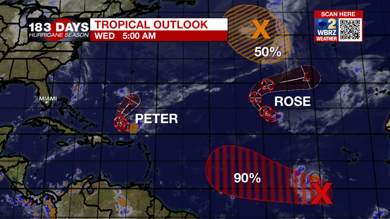
Peter and Rose have both been downgraded to tropical depressions as they move north in the open Atlantic. None of the tropical activity is currently a threat to the local area.
Trending News
Showers and thunderstorms are becoming better organized in association with a tropical wave located several hundred miles southwest of the Cabo Verde Islands. However, satellite wind data indicate that the system still lacks a well-defined center. Environmental conditions are expected to remain conducive for additional development, and a tropical depression is likely to form in a day or two while the system moves westward at 10 to 15 mph across the eastern and central tropical Atlantic Ocean. There is a 90% chance of formation in the next 5 days.
A gale-force, non-tropical low pressure system, the remnants of Odette, is located about 500 miles west of the westernmost Azores. This low could acquire some subtropical characteristics over marginally warm waters during the next few days while it makes a counter-clockwise loop over the north-central Atlantic Ocean. However, by the weekend, this system is expected to move into an environment of strong upper-level winds. Additional information on this system, including gale warnings, can be found in High Seas Forecasts issued by the National Weather Service. There is a 50% chance of formation in the next 5 days.
The WBRZ Weather Team is watching the tropics around the clock and will bring you updates as they come. Click here to visit the Hurricane Center.
Need weather conditions HOUR BY HOUR? Get hour by hour weather and right now weather conditions for your location on the WBRZ WX App on your Apple or Android device. Follow WBRZ Weather on Facebook and Twitter for even more weather updates and unique weather insight from the whole team!
More News
