

Latest Weather Blog
Thursday PM Forecast: Scattered downpours continue, drier air may come next week
The National Weather Service has continued the FLASH FLOOD WATCH through Friday for all local parishes and counties EXCEPT Amite, East Feliciana, Pointe Coupee and West Feliciana and Wilkinson. The remains of Nicholas continue to spin near Lafayette with copious amounts of gulf moisture continuing to stream into the area. Overall, additional rain amounts will be manageable in the range of 1 to 3 inches. However, since a widespread 5 to 10 inches of rain has fallen since Monday, the rainfall rates will be a bigger issue. Thanks to our highly saturated grounds, any intense rain in a short time will lead to run off and drainage problems.
?? - More than 2 feet "ahead of schedule" the ridiculously wet run continues... interestingly, if you remove the two anomalies (8/16 Flood and 5/17/21), this year would be the wettest to date. #BatonRouge #LaWX #MsWX pic.twitter.com/xBXUbM1tVW
— Josh Eachus (@DrJoshWX) September 16, 2021
Next 24 Hours: The overnight hours will be quieter than last but spotty showers will stay in the forecast. Low temperatures will stop in the low 70s. On Friday, some sun may sneak out early in the day. High temperatures will respond to any dry time by reaching the mid 80s. Especially with daytime warming, the remnants of Nicholas will trigger scattered to widespread showers and thunderstorms and any associated downpours could lead to isolated flooding issues.
Up Next: Saturday through Monday, the weather pattern will resemble an active summertime setup. Leftover moisture from Nicholas and an upper level pool of unstable air will cause scattered showers and thunderstorms to develop each day as temperatures warm. Brief downpours will be possible. At this time, no washouts are expected, but many places could see some rain each day. The total rainfall forecast through next week should not exceed 3 inches in any one spot. However, if those amounts fall in a short time on a small area, some isolated flooding issues could occur. A cold front, possibly a substantial one, will push into the area and dry things out by Wednesday night. CLICK HERE for your full 7-Day Forecast.
Trending News
The Tropics: Showers and thunderstorms associated with a tropical wave west-southwest of the Cabo Verde Islands have become less organized since yesterday. However, environmental still allow an 80 percent chance that a tropical depression forms over the weekend as this system moves west-northwestward across the tropical Atlantic.
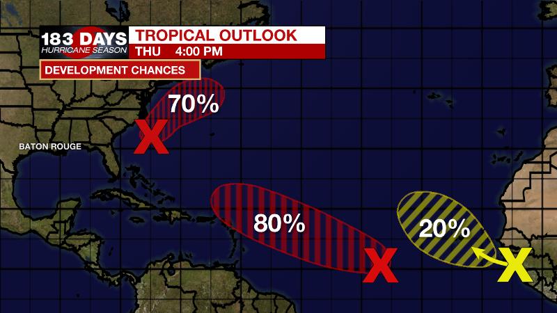
Shower and thunderstorm activity associated with a broad area of low pressure located a couple of hundred miles southeast of North Carolina is beginning to show signs of organization. However, recent satellite wind data suggest that the system currently lacks a well-defined center. Conditions support additional development, and there is a 70 percent chance that a tropical depression forms during the next day or so while the system moves northeastward off the mid-Atlantic U.S. coasts.
Disorganized cloudiness and thunderstorms over the far eastern tropical Atlantic are associated with a tropical wave along the west coast of Africa. Environmental conditions are forecast to be only marginally conducive, and development, if any, of this system should be slow to occur over the next few days while the system moves northwestward over the far eastern Atlantic.
For the latest tropical forecasts, advisories and information, visit the WBRZ Hurricane Center as we navigate all 183 Days of Hurricane Season.
The Explanation: Through Friday, the remnants of Nicholas fizzle over south Louisiana. In the upper levels of the atmosphere, a weak trough of low pressure will center just west of the local area to allow increased lift. At the same time, total moisture content in the atmosphere, precipitable water, will remain well above average for the time of year. Therefore, the potential for heavy showers will continue on Friday. While the activity may present more scattered in nature on radar, downpours on top of saturated soils could quickly lead to localized flooding issues. Over the weekend and into early next week, an upper level trough will remain close enough to the area to maintain instability while tropical moisture continues to linger. Daytime heating will become the primary force in triggering showers and thunderstorms.
By Wednesday, a cold front will approach from the north. It’s still early in the season for guaranteed cold fronts, but if this one comes through as displayed on forecast model guidance right now, it could mean the coolest and driest air since last spring.
--Josh
The WBRZ Weather Team is here for you, on every platform. Your weather updates can be found on News 2, wbrz.com, and the WBRZ WX App on your Apple or Android device. Follow WBRZ Weather on Facebook and Twitter for even more weather updates while you are on the go.
More News
