

Latest Weather Blog
Rainy Thursday ahead, will it break for weekend?
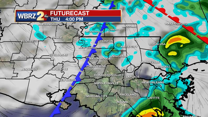
Times of rain are expected on Thursday. Fortunately, the culprit storm system will only stick around for about 12 hours and will clear the area in time for your Friday.
5:40am: Do expect a rather messy morning drive. A moderate batch of rain is crossing the Atchafalaya Basin and should affect the #BatonRouge area around 6:30am. Rain will become less widespread by afternoon. #2uneIn to @WBRZ for the latest! #LaWX pic.twitter.com/3qjrDdeWpM
— Josh Eachus (@DrJoshWX) January 23, 2020
THE FORECAST:
Today and Tonight: A surface low and associated fronts will cross the Baton Rouge area on Thursday producing periods of rain and possibly embedded thunderstorms—especially during the morning hours. As showers become less widespread and more scattered in nature during the afternoon hours, a glimpse or two of sunshine is possible. A brief advance of Gulf air due to southerly winds behind a warm front will allow temperatures to approach the low 60s. However, the trailing cold front will sweep through this evening, skies will rapidly clear and light, west winds will result in overnight low temperatures easing back into the mid 40s.
Up Next: Friday and Saturday will feature mostly sunny skies and seasonable temperatures. That is, highs will be in the low 60s with lows in the upper 30s and low 40s. A fast-moving disturbance will move through the region on Sunday, and while it previously looked like this would pass dry, there are now signs that enough moisture will be available to produce a few showers. Another dry day or two is expected early next before the next weak storm system moves into the region around Wednesday.
THE EXPLANATION:
Trending News
An upper level trough and associated surface frontal system will move across the area on Thursday maintaining unsettled weather. Working with ample moisture, these features will produce enough lift for periods of rain—especially early. There could be some thunderstorm development but none will be severe. High resolution models suggest that the steadiest and heaviest rain will exit by noon.
A dry slot in the mid-levels of the atmosphere associated with this storm system will cut into the area around midday, shutting down much of the precipitation. Some wrap around moisture may continue clouds and scattered showers into the afternoon but due to that drier mid level air, some peeks of sun will actually be possible. Thermometers could sneak up into the 60s due to the brief advance of Gulf moisture. The whole complex will shift east by Friday and expect a nice drying trend leading into the weekend. Because the current storm system has Pacific and not Canadian origins, no significant cooling will occur behind the front. Near average temperatures are projected for the weekend. A fast-moving shortwave trough of low pressure in the upper levels of the atmosphere will move across the central Gulf Coast states on Sunday. Models have gotten more aggressive in displaying rain and some thunderstorms across the area before the system moves east and ends rain by Monday morning. Overall, no significant impact is expected from this disturbance and the weather will be quiet to begin next week. The active upper level pattern will continue though and yet another low pressure system will pass through the area on Wednesday.
--Josh
The WBRZ Weather Team is here for you, on every platform. Your weather updates can be found on News 2, wbrz.com, and the WBRZ WX App. on Apple and Android devices. Follow WBRZ Weather on Facebook and Twitter for even more weather updates while you are on the go.
More News
