

Latest Weather Blog
Monday PM Forecast: cold front to deliver big temperature changes
Look for one more day of humid, tropical weather. Then, the first substantial cold front of the fall season will bring much more comfortable temperatures to the area on the first day of astronomical fall!
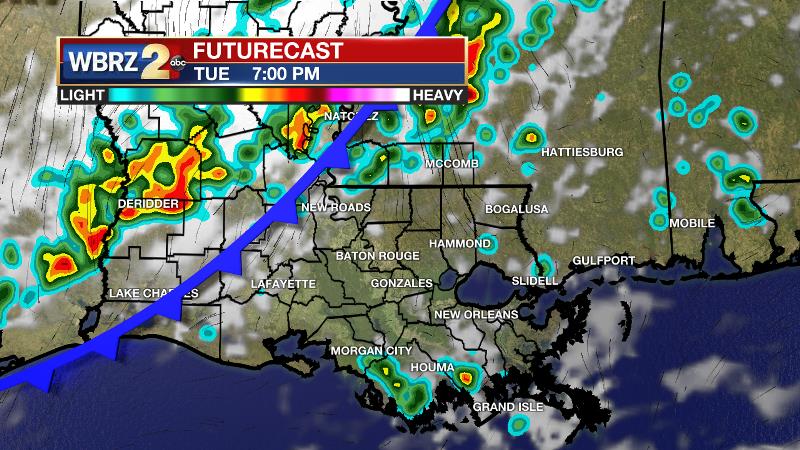
Next 24 Hours: The nighttime hours will remain muggy and uncomfortable with low temperatures stopping in the low 70s. A bit of fog could develop near dawn. Some sunshine will be around on Tuesday to drive high temperatures close to 90 degrees. With plenty of humidity, it could feel like 100 degrees for a little while. Scattered showers and thunderstorms are anticipated, but coverage should be a bit lower than previous days and mainly during the afternoon hours. During the evening hours, a cold front will come into the area and possibly bring a broken, weak line of showers and thunderstorms with it.
Up Next: Behind a cold front, skies will clear from northwest to southeast on Wednesday morning. While temperatures will start in the upper 60s, a stern northwest breeze will prevent substantial warming, despite the return of sunshine. Thermometers will barely get back to the 80s. Get ready for a run of pleasant weather from there! Thursday through Sunday will feature clear skies, no rain chances, no humidity, highs in the upper 70s and low 80s and lows in the mid to upper 50s! CLICK HERE for your full 7-Day Forecast.
Trending News
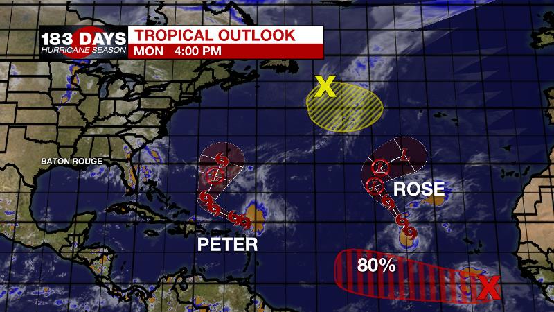
The Tropics: The tropics are busy, but not threatening to the United States. Tropical Storm Peter is battling off wind shear north of the Leeward Island. It will stay north of Puerto Rico and the Bahamas while turning northward and weakening later this week. Tropical Storm Rose is struggling to strengthen over the eastern Atlantic and will continue to struggle through the end of the week while drifting aimlessly at sea. A tropical wave south of the Cabo Verde Islands has an 80 percent chance of becoming a tropical depression as it moves westward over the southeast Atlantic this week. The remnants of Tropical Storm Odette over the north Atlantic have a 30 percent chance of acquiring subtropical characteristics as it drifts slowly south later this week.
For the latest tropical forecasts, advisories and information, visit the WBRZ Hurricane Center as we navigate all 183 Days of Hurricane Season.
The Explanation: An upper level trough and remnant tropical moisture will control the weather pattern through Tuesday afternoon. This combination will keep humid conditions and afternoon instability as temperatures warm into the upper 80s and therefore spark scattered showers and thunderstorms. A sharper upper level trough will enter the region on Tuesday night. An associated cold front will move in from the northwest. All of the supporting mechanisms for showers and thunderstorms will be well north of the area so it appears that with an overnight passage, some humidity and lift is all that will be available to produce a narrow, broken band of showers. Any rain will move offshore by Wednesday afternoon. On the other side of the front, northwesterly winds will usher in the coolest air since May. In fact, the temperature effects will be noticed as early as Wednesday afternoon as high temperatures struggle to get back to 80 degrees. From there, a run of night sin the mid 50s is anticipated! Thursday through Sunday will be dry and comfortable with clear skies, highs in the upper 70s to low 80s and lows in the mid to upper 50s. By early next week, a ridge of high pressure will build overhead leading to warmer afternoons. However, associated sinking air and a dry atmosphere will keep rain off the forecast board.
--Josh
The WBRZ Weather Team is here for you, on every platform. Your weather updates can be found on News 2, wbrz.com, and the WBRZ WX App on your Apple or Android device. Follow WBRZ Weather on Facebook and Twitter for even more weather updates while you are on the go.
More News
