

Latest Weather Blog
CSU predicts above average activity for 2020 hurricane season
In an annual extended Atlantic Basin hurricane season forecast, tropical experts at Colorado State University are projecting slightly above normal activity for the 2020 season. Their outlook calls for 16 named storms and 8 hurricanes with 4 being considered major (category 3 strength or higher). Annual averages are 12 named storms, 6 hurricanes and 3 major hurricanes.
Dr. Philip Klotzbach and the research team cited an absence of El Niño the potential for weak La Niña conditions by the middle of summer. Additionally, sea surface temperatures across the Atlantic Basin are slightly above average and are forecast to remain that way.
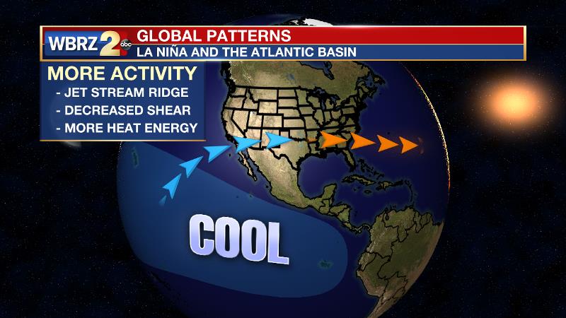
La Niña is a pattern, which favors much more activity in the Atlantic Basin during hurricane season. During La Niña, trade winds weaken over the Atlantic Ocean creating a supportive environment for tropical cyclone formation.
Warm sea surface temperatures enhance evaporation and cloud development. In the presence of favorable winds, heat energy from the oceans promotes tropical cyclone strengthening.
Some other probabilities given are as follows:
Trending News
At least one major (category 3-5) hurricane landfall on each of the following coastal areas:
-Entire U.S. coastline: 69% (average for last century is 52%)
-U.S. East Coast Including Peninsula Florida: 45% (average for last century is 31%)
-Gulf Coast from the Florida Panhandle westward to Brownsville: 44% (average for last century is 30%)
As defined by the National Oceanic and Atmospheric Administration (NOAA), El Niño and La Niña are the warm and cool phases of a recurring climate pattern across the tropical Pacific—the El Niño-Southern Oscillation, or “ENSO” for short. Keep in mind that El Niño and La Niña do not “cause” any one specific weather event; rather the two phases of ENSO influence change in global climate patterns that then increase the likelihood of specific weather events. Once again, ENSO is not “to blame” for any one storm system, temperature anomaly or hurricane. If La Niña does indeed develop, the Atlantic Basin faces an increased chance at above average tropical activity. Despite higher chances, it is much too early to determine where storms will develop or where they will go.
The forecast is based on an extended-range early April statistical prediction scheme that was developed using 38 years of past data. These seasonal forecasts were originally developed by the late Dr. William Gray, who was lead author on these predictions for over 20 years and continued as a co-author until his death in 2018. You can review the entire prediction, the scientific explanation and the reason such a forecast is made, RIGHT HERE. Seasonal updates are issued on June 1 and August 3.
The researchers at Colorado State University and the WBRZ Weather Team remind that “it only takes one hurricane making landfall to make it an active season for you,” so prepare accordingly. NOAA’s official outlook is expected in Late May. For more on the season ahead and preparedness, visit wbrz.com/weather and click on the hurricane center.
More News
