

Latest Weather Blog
Chap stick conditions to continue through the weekend
Breezy and cool conditions will carry us into the weekend. The chance for precipitation continues to look quite low and will hold off well into next week.
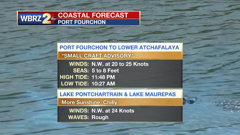
The Next 24 Hours: Winds once again make for a challenging low temperature forecast. Clear skies and very dry air would normally create ideal cooling conditions overnight. However, elevated winds out of the northwest may stop maximum cooling. Lows will likely bottom out in the low to mid 30s for most neighborhoods. Saturday will be sunny with highs temperatures in the mid 50s. Winds will stay out of the west-northwest at 10-15mph. If you find yourself reaching for the lotion and chap stick, it is because the air is extremely dry. Daytime relative humidity will be around 20-30 percent. These two features make favorable conditions for fire ignition and spread so it would be a good idea to reconsider outdoor burning, including bonfires. Additionally, the strong winds will make for a rough, choppy days on the lakes and Gulf.
After That: After a morning low near freezing, Sunday’s high temperature will roll into the mid 50s as some clouds pass through ahead of another weak and cold front. Little or no precipitation is expected. Temperatures will begin to moderate on Monday. Highs could be back in the 70s by Tuesday and stay there for a few days. A storm system that develops in the southwest United States could fling some showers our way by the end of next week. CLICK HERE to view your complete 7-Day Forecast.
The Explanation: Due to a deep upper level trough, behind this boundary, lows will again flirt with freezing both weekend mornings. Another weak upper level trough and associated cold front will move into the Southeast on Sunday, but the lack of available moisture will bring nothing more than some increased cloud cover. The basin of the trough, and therefore the coldest air, will remain north of the local area. Monday through Thursday, a broad upper level ridge will develop over Gulf Coast states leading to warmer than average temperatures. The ridge will be directly overhead on Monday and Tuesday leading to mainly clear skies. Meanwhile, a slower moving upper level trough will pinch off from the jet stream over the Southwest. The associated surface low may move over the Texas coastal plain by the middle of next week. Deep southwest flow in will allow moisture to increase at all levels of the atmosphere and clouds will be on the build Wednesday. Nights will be milder and likely foggy. Some showers could begin as early as Wednesday. Forecast models show the weakening trough moving north of the region on Friday with an associated cold front. After some showers, a slightly colder air mass may arrive by next weekend.
Trending News
--Josh
The WBRZ Weather Team is here for you, on every platform. Your weather updates can be found on News 2, wbrz.com, and the WBRZ WX App on your Apple or Android device. Follow WBRZ Weather on Facebook and Twitter for even more weather updates while you are on the go.
More News
