

Latest Weather Blog
Another Fabulous Day for your Friday
THE FORECAST:
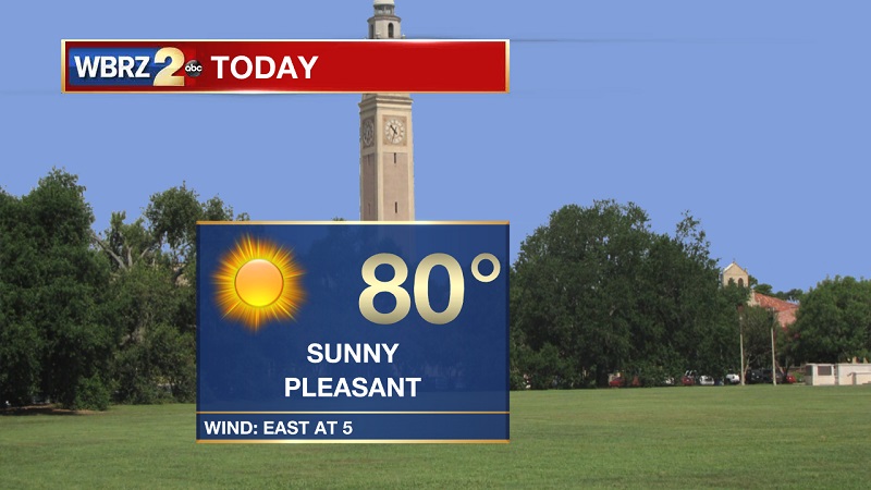
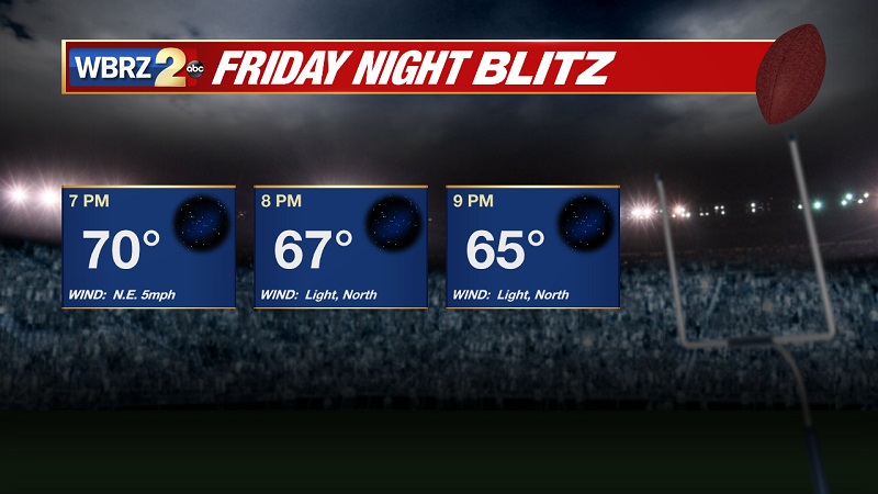
Today and Tonight: Another beautiful fall day ahead, with temperatures this morning starting off in the mid to upper 50s. Conditions will warm quickly through the morning, reaching in the upper 70s around lunch, with highs reaching around 80° through the afternoon. Dew points forecast to slowly increase through the 50s today. Skies will stay clear through the day and tonight, as high pressure sets up camp. Temperatures to drop quickly tonight, into the 60s near 8 PM, as overnight lows approach around 58° early Saturday morning.
Up Next: A cold front is slowly approaching from the west, helping to increase humidity and cloud cover through the weekend. Showers return on Monday, as the front stalls over our area to keep isolated showers in the forecast until Wednesday.

The Tropics
Trending News
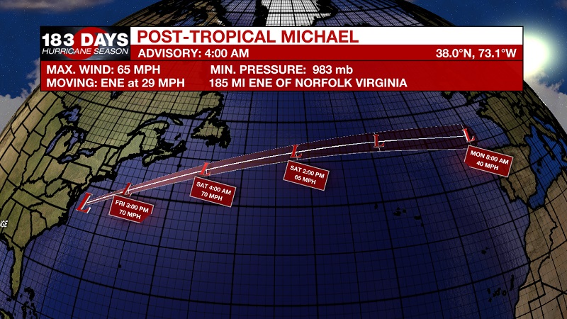
Michael is now a post-tropical cyclone as he moves away from the United States. Currently, Michael is located about 185 miles east-northeast of Norfolk, Virginia and about 275 miles southwest of Nantucket, Massachusetts. Maximum sustained winds are at 65 mph, and moving east-northeast at 29 mph. This motion is expected to continue with an increase in forward speed during the next couple of days. On the forecast track, the center of Michael will move away from the United States today and move rapidly across the open Atlantic Ocean tonight through Sunday. Some additional strengthening is expected today and tonight as the post-tropical cyclone moves across the Atlantic.
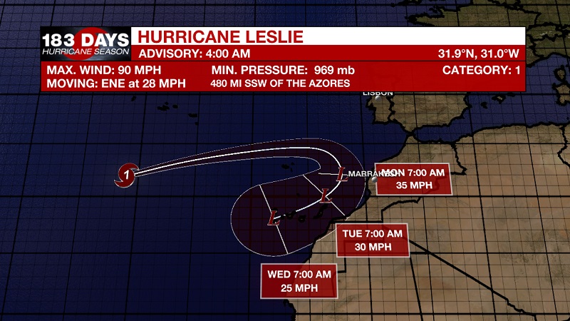
Hurricane Leslie moving quickly toward the east-northeast over the eastern Atlantic. Currently located about 480 miles south-southwest of the Azores with 90 mph sustained winds, and moving east-northeast at 28 mph. A continued east-northeast motion with an increase in forward speed is expected through Friday. Leslie is forecast to slow down and turn toward the east or east-southeast by Saturday. On the forecast track, Leslie will pass near Madeira Island by late Saturday. Weakening is forecast during the next 72 hours, and Leslie could transition into a post-tropical low by Sunday or Sunday night.
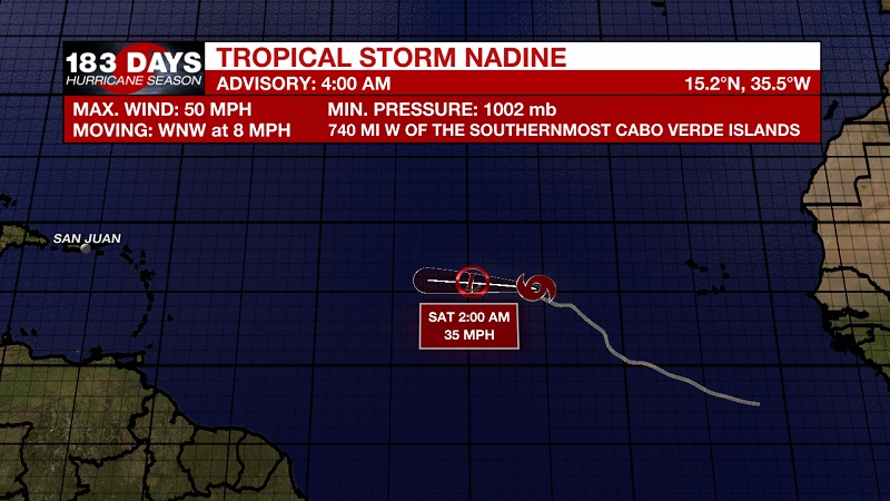
Tropical Storm Nadine beginning to unravel. Currently located about 740 miles west of the Cabo Verde Islands with sustained winds of 50 mph, and moving toward the west-northwest at 8 mph. A west-northwestward to westward motion with an increase in forward speed is expected through the weekend. Weakening is forecast during the next couple of days, and Nadine is expected to dissipate by Sunday.
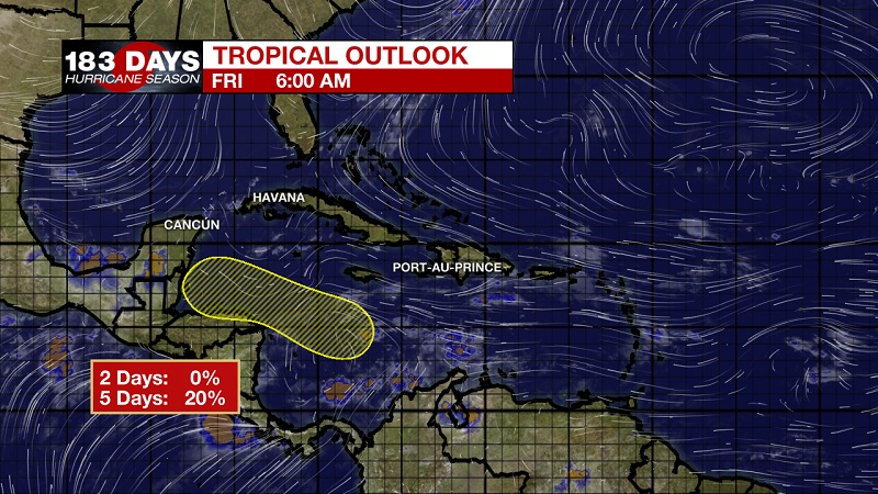
We are also keeping our eyes on a broad area of low pressure that could form over the west-central Caribbean Sea in a day or two and then move slowly westward toward Central America through early next week. Environmental conditions are becoming less favorable for tropical cyclone formation. The National Hurricane Center is forecasting a 0% chance of tropical development over the next 2 days, and that increases to only a 20% chance within the next 5 days.
THE EXPLANATION:
High pressure behind the cold front that has broken through the Gulf and now is draping across Southern Florida. This high pressure will linger in Louisiana today and begin to move toward the northeast through the weekend ahead of another cold front that will travel through the Gulf early in the week. As the front will approaches, temperatures and dew points will increase on Sunday, before showers and isolated storms push through Monday and Tuesday. Lingering showers could stay into Wednesday, but highs will drop back into the mid-70s through the latter half of the workweek.
--Meteorologist Matt Callihan
The WBRZ Weather Team is here for you, on every platform. Your weather updates can be found on News 2, and the WBRZ WX App. on Apple and Android devices. Follow WBRZ Weather on Facebook and Twitter for even more weather updates while you are on the go.
More News
